Military Maps of Scotland (18th century)
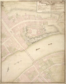
| Title: | A plan of part of the town of Inverness with a project for Barracks on Castle Hill … |
| Name: | Romer, John Lambertus (Engineer) [Wade, George (Engineer)] |
| Description: | 1 manuscript map : col. (mainly in red) ; 458 x 355 mm., on sheet, 474 x 370 mm. |
| Original Survey: | 1728 |
| Date on Map: | 1728 |
| Placename: | Fort George (Inverness) |
| Parish: | Inverness and Bona |
| County: | Inverness-shire |
| Shelfmark: | Acc.10497 Wade.58j |
| Zoom Into Map: | Click on the map to view in greater detail. |
All images © National Library of Scotland