Military Maps of Scotland (18th century)
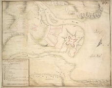
| Title: | A plan of the intended Fortress with the Situation of Killiwhymen |
| Name: | Romer, John Lambertus (Engineer) [Wade, George (Engineer)] |
| Description: | 1 manuscript map : col. ; 350 x 448 mm., on sheet, 382 x 463 mm. |
| Original Survey: | [1729?] |
| Date on Map: | [1729?] |
| Placename: | Fort Augustus |
| Parish: | Boleskine and Abertarff |
| County: | Inverness-shire |
| Shelfmark: | Acc.10497 Wade.58h |
| Zoom Into Map: | Click on the map to view in greater detail. |
All images © National Library of Scotland