Military Maps of Scotland (18th century)
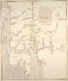
| Title: | A Map of Part of the Highlands, not done by actual Survey, but laid down on the common computed distances of places … |
| Name: | [Wade, George (Engineer)] |
| Description: | 1 manuscript map : col. outlines in red ; 534 x 443 mm., on sheet, 573 x 472 mm. |
| Original Survey: | [ca. 1724-45?] |
| Date on Map: | [ca. 1724-45?] |
| Shelfmark: | Acc.10497 Wade.58c |
| Zoom Into Map: | Click on the map to view in greater detail. |
All images © National Library of Scotland