Military Maps of Scotland (18th century)
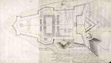
| Title: | Outline of the East End of Fort George with References to the Estimate for Works & Repairs proposed for that place, in the year 1787. |
| Name: | Shipley, Sir Charles (Engineer) |
| Description: | 1 manuscript map ; 381 x 664 mm. |
| Original Survey: | 1787 |
| Date on Map: | 1787 |
| Placename: | Fort George (Ardersier) |
| Parish: | Ardersier |
| County: | Inverness-shire |
| Shelfmark: | MS.1650 Z.46/57i |
| Zoom Into Map: | Click on the map to view in greater detail. |
All images © Crown Copyright and © National Library of Scotland