Military Maps of Scotland (18th century)
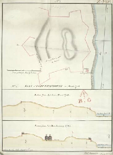
| Title: | Plan of Fort Charlotte in March 1781 No. 1; Section from A to B in March 1781; Section from A to B January 1783 [copy] |
| Name: | Frazer, Andrew (Engineer) Field, John (Copyist) |
| Description: | 1 manuscript map ; 448 x 335 mm., on sheet, 478 x 356 mm. |
| Original Survey: | 1812 |
| Date on Map: | 1812 |
| Placename: | Fort Charlotte |
| Parish: | Lerwick |
| County: | Shetland |
| Shelfmark: | MS.1649 Z.03/48c |
| Zoom Into Map: | Click on the map to view in greater detail. |
All images © Crown Copyright and © National Library of Scotland