Military Maps of Scotland (18th century)
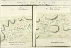
| Title: | Survey of the different parts of the Road joyned betwixt Blair Gowrie and Brae Mar; Made by a Detachment of one Hundred Men of Lord Viscount Bury's Regt. in the Year 1750 [copy] |
| Name: | Morrison, George (Engineer) Castleman, Henry (Copyist) |
| Description: | 1 manuscript map ; 384 x 649 mm., on sheet, 462 x 689 mm. |
| Original Survey: | 1779 |
| Date on Map: | 1779 |
| County: | Perthshire, Aberdeenshire |
| Shelfmark: | MS.1649 Z.03/38b |
| Zoom Into Map: | Click on the map to view in greater detail. |
All images © Crown Copyright and © National Library of Scotland