Military Maps of Scotland (18th century)
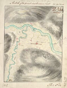
| Title: | Sketch of the ground about Braemarr Castle |
| Name: | Watson, David (Engineer) |
| Description: | 1 manuscript map ; 200 x 152 mm., on sheet, 235 x 183 mm. |
| Original Survey: | 1748 |
| Date on Map: | 1748 |
| Placename: | Braemar Castle |
| Parish: | Crathie and Braemar |
| County: | Aberdeenshire |
| Shelfmark: | MS.1649 Z.03/32c |
| Zoom Into Map: | Click on the map to view in greater detail. |
All images © Crown Copyright and © National Library of Scotland