Military Maps of Scotland (18th century)
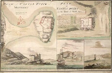
| Title: | Plan of Castle Tyrim in Muydart; Plan of Castle Duirt in the Island of Mull 1748 |
| Name: | Watson, David (Engineer) Sandby, Paul (Draughtsman) |
| Description: | 1 manuscript map ; 327 x 526 mm., on sheet, 363 x 545 mm. |
| Original Survey: | 1748 |
| Date on Map: | 1748 |
| Placename: | Tioram, Castle Duart |
| Parish: | Ardnamurchan, Torosay |
| County: | Inverness-shire |
| Shelfmark: | MS.1648 Z.03/28e |
| Zoom Into Map: | Click on the map to view in greater detail. |
All images © Crown Copyright and © National Library of Scotland