Military Maps of Scotland (18th century)
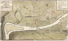
| Title: | An Exact Plan of the Town and Adjacent parts of Perth as it was Fortified and Possess'd by the Rebells in Scotland till they were driven thence, by the Victorious Arms of King George Anno 1715/6 [copy]. |
| Name: | Horneck, William (Engineer) |
| Description: | 1 manuscript map ; 406 x 681 mm., on sheet, 435 x 726 mm. |
| Original Survey: | 1715-16 |
| Date on Map: | 1715-16 |
| Placename: | Perth |
| Parish: | Perth |
| County: | Perthshire |
| Shelfmark: | MS.1647 Z.03/02b |
| Zoom Into Map: | Click on the map to view in greater detail. |
All images © Crown Copyright and © National Library of Scotland