Military Maps of Scotland (18th century)
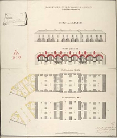
| Title: | Plan, Elevation & Section of the Arsenal & Armoury; Marked No. 4 in the General Plan [1746] [Proposed Fort George on Oliver's Fort site, Inverness] |
| Name: | Marcell, Lewis (Engineer) |
| Description: | 1 manuscript map ; 624 x 528 mm., on sheet, 650 x 545 mm. |
| Original Survey: | [1746] |
| Date on Map: | [1746] |
| Placename: | Fort George (Inverness) |
| Parish: | Inverness and Bona |
| County: | Inverness-shire |
| Shelfmark: | MS.1647 Z.02/81c |
| Zoom Into Map: | Click on the map to view in greater detail. |
All images © Crown Copyright and © National Library of Scotland