Military Maps of Scotland (18th century)
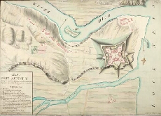
| Title: | Plan of Fort Augustus shewing the repairs and Additions done between Iune and September 1747. with the Works proposed to be Compleated in 1748 [copy] |
| Name: | Skinner, William (Engineer) T.C. (Copyist) |
| Description: | 1 manuscript map ; 526 x 737 mm., on sheet, 540 x 737 mm. |
| Original Survey: | 1747 |
| Date on Map: | 1747 |
| Placename: | Fort Augustus |
| Parish: | Boleskine and Abertarff |
| County: | Inverness-shire |
| Shelfmark: | MS.1647 Z.02/66c |
| Zoom Into Map: | Click on the map to view in greater detail. |
All images © Crown Copyright and © National Library of Scotland