Military Maps of Scotland (18th century)
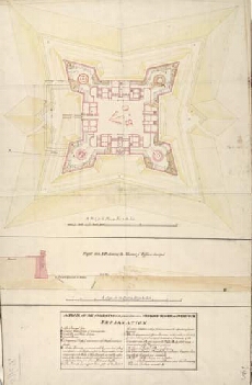
| Title: | A Plan of Fort Augustus in its present State with a Designd Fossee & Cover'd Way [1747] |
| Name: | Skinner, William (Engineer) |
| Description: | 1 manuscript map ; 693 x 447 mm., on sheet, 709 x 458 mm. |
| Original Survey: | 1747 |
| Date on Map: | 1747 |
| Placename: | Fort Augustus |
| Parish: | Boleskine and Abertarff |
| County: | Inverness-shire |
| Shelfmark: | MS.1647 Z.02/65a |
| Zoom Into Map: | Click on the map to view in greater detail. |
All images © Crown Copyright and © National Library of Scotland