Military Maps of Scotland (18th century)
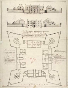
| Title: | The Plan of Fort Augustus, in the Highlands of Scotland (a modern fortification, Copied from the delineation of Captn John Romer, Engineer). This fortification was begun in 1729, & finish'd in 1742. |
| Name: | Romer, John Lambertus (Engineer) |
| Description: | 1 manuscript map ; 643 x 488 mm., on sheet, 682 x 529 mm. |
| Original Survey: | ca.1742? |
| Date on Map: | [1742] |
| Placename: | Fort Augustus |
| Parish: | Boleskine and Abertarff |
| County: | Inverness-shire |
| Shelfmark: | MS.1647 Z.02/63 |
| Zoom Into Map: | Click on the map to view in greater detail. |
All images © Crown Copyright and © National Library of Scotland