Military Maps of Scotland (18th century)
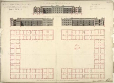
| Title: | Plan and Elevations with Sections of the Barracks for 1600 Men and Officers Fort George 1753 |
| Name: | Skinner, William (Engineer) Tarrant, Charles (Draughtsman) |
| Description: | 1 manuscript map ; 526 x 736 mm., on sheet, 548 x 754 mm. |
| Original Survey: | 1753 |
| Date on Map: | 1753 |
| Placename: | Fort George (Ardersier) |
| Parish: | Ardersier |
| County: | Inverness-shire |
| Shelfmark: | MS.1646 Z.02/50a |
| Zoom Into Map: | Click on the map to view in greater detail. |
All images © Crown Copyright and © National Library of Scotland