Military Maps of Scotland (18th century)
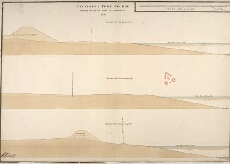
| Title: | Sections of Fort George Shewing how far the Works are Executed in 1750; Section thro' the Line 13.14; Section thro' the Line 15.16; Section thro' the Line 17.18. |
| Name: | Skinner, William (Engineer) Tarrant, Charles (Draughtsman) |
| Description: | 1 manuscript map ; 507 x 726 mm., on sheet, 555 x 763 mm. |
| Original Survey: | 1750 |
| Date on Map: | 1750 |
| Placename: | Fort George (Ardersier) |
| Parish: | Ardersier |
| County: | Inverness-shire |
| Shelfmark: | MS.1646 Z.02/43a |
| Zoom Into Map: | Click on the map to view in greater detail. |
All images © Crown Copyright and © National Library of Scotland