Military Maps of Scotland (18th century)
Your search returned 33 records.
Ordered chronologically (undated items first).
| Title: | Description of the forts of Inverloughee. | |
| Survey: | 1656 | |
| Shelfmark: | EMS.s.89 | |
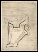
| Title: | Barracks at Inverlochy with Officers Houses | |
| Name: | Jelfe, Andrews (Architect) | |
| Survey: | 1709 | |
| Shelfmark: | MS.1646 Z.02/32b | |
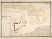
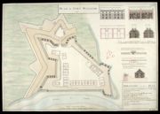
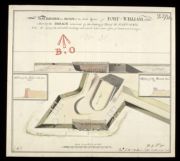
| Title: | Plan of Fort William at Inverlochy in its present condition Augst. 1709 | |
| Name: | [Dury, Theodore (Engineer)] | |
| Survey: | 1709 | |
| Shelfmark: | MS.1646 Z.02/24c | |

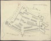
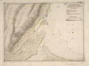
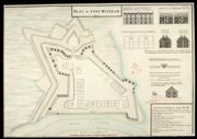
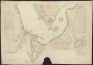
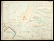
| Title: | Plan of Fort William with the country adjacent | |
| Name: | Johnson, Robert (Overseer) | |
| Survey: | [ca.1710] | |
| Shelfmark: | MS.1646 Z.02/24a | |
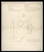
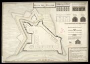
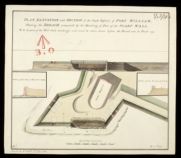
| Title: | Plan of Fort William at Inverlochie in Lochaber | |
| Name: | [Dury, Theodore (Engineer)] | |
| Survey: | [ca.1710] | |
| Shelfmark: | MS.1646 Z.02/24b | |
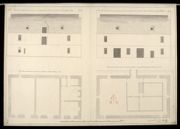
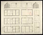
| Title: | [Plan of the Storehouse, Fort William]; The Front of the new Store house as it appears to the Rampart, built 1712, Fort William, H; The Front of the new Store house as it appears to the Parade, Built in ye year 1712, Fort William; The Plan of the new Stor | |
| Name: | Petit, Lewis (Engineer) | |
| Survey: | 1712 | |
| Shelfmark: | MS.1646 Z.02/25a | |
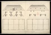
| Title: | [Plans of the Soldiers' Barracks, Fort William]; The front of ye Souldiers Barracks as it appears to the Rampart, Fort William, K; The Front of the Soldiers Barracks as it appears to the Parade, Fort William, K; A Plan of the Souldiers Barracks that is ne | |
| Name: | Petit, Lewis (Engineer) | |
| Survey: | 1712 | |
| Shelfmark: | MS.1646 Z.02/25b | |
| Title: | Fort William, Anno 1719 [No.1] | |
| Name: | Jelfe, Andrews (Architect) Moore, Thomas (Engineer) | |
| Survey: | 1719 | |
| Shelfmark: | MS.1646 Z.02/26a | |
| Title: | Fort William, Anno 1719 [No.1] [copy] | |
| Name: | Jelfe, Andrews (Architect) Moore, Thomas (Engineer) Dodd, Pressick (Copyist) | |
| Survey: | 1719 | |
| Shelfmark: | MS.1646 Z.02/26b | |
| Title: | Fort William, Anno 1719 [No.2] | |
| Name: | Jelfe, Andrews (Architect) Moore, Thomas (Engineer) | |
| Survey: | 1719 | |
| Shelfmark: | MS.1646 Z.02/26c | |
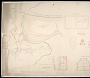
| Title: | [Plan of] District of Fort Wm. | |
| Name: | [Wade, George (Engineer)] | |
| Survey: | 1728 | |
| Shelfmark: | Acc.10497 Wade.58i | |
| Title: | Fort William; Fort Augustus; Fort George, Inverness | |
| Name: | Romer, John Lambertus (Engineer) Jackson, Leonard (Draughtsman) | |
| Survey: | [ca.1729-46] | |
| Shelfmark: | MS.1646 Z.02/31c | |
| Title: | Profiles and Elevations Relating to the Plan of Fort William, 1733 | |
| Name: | Romer, John Lambertus (Engineer) Massey, George & Coombs, Richard (Copyist) | |
| Survey: | 1733 | |
| Shelfmark: | MS.1646 Z.02/27c | |
| Title: | [Plan showing fortifications of Fort William and Town of Maryborough.] | |
| Name: | [Wade, George (Engineer)] | |
| Survey: | [ca. 1736?] | |
| Shelfmark: | Acc.10497 Wade.58o | |
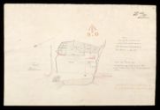
| Title: | A Plan of Fort William in the Shire of Inverness, with the District as is described by the Occult lines markt with yel=low & bounded by the River Navis. | |
| Name: | [Wade, George (Engineer)] | |
| Survey: | 1736 | |
| Shelfmark: | Acc.10497 Wade.58p | |
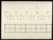
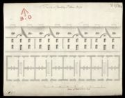
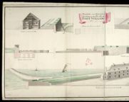
| Title: | A Draught of the long Soldjers Barrack already built at Fort William, along Nevish Watter side | |
| Name: | Petit, Lewis (Engineer) | |
| Survey: | [ca.1744?] | |
| Shelfmark: | MS.1646 Z.02/32a | |
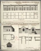
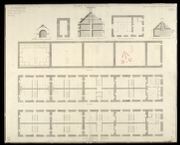
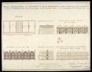
| Title: | Plan of Ground Story of the Long Pile of Barracks at Fort-William, lately Repaired; Plan, Elevation and Section of the Bakehouse Built at Fort-William 1743; Plan and Elevation of the Main Gate proposed to be Built at Fort-William 1744; Plan and Elevation | |
| Name: | Campbell, Dugal (Engineer) | |
| Survey: | 1744 | |
| Shelfmark: | MS.1646 Z.02/28a | |
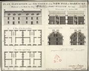
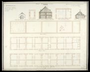
| Title: | Plan, Elevation and Sections of the New Pile of Barracks Ordered to be Built for the Officers at Fort-William | |
| Name: | Campbell, Dugal (Engineer) | |
| Survey: | 1744 | |
| Shelfmark: | MS.1646 Z.02/28b | |
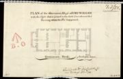
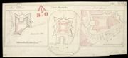
| Title: | Plan of the Governour's House at Fort-William with the Closets that is joined to the Gable End coloured Red shewing where the Fire happened | |
| Name: | Campbell, Dugal (Engineer) | |
| Survey: | 1744 | |
| Shelfmark: | MS.1646 Z.02/28c | |
| Title: | Plan of the Front on the Entrance to Fort William, representing the Main Gate Way as proposed to be rebuilt with the Wing Walls sustaining the ground of the Rampart on each side of the Entrance. And the manner proposed for forming the Earth Work of the R | |
| Name: | Campbell, Dugal (Engineer) Deleny, John (Copyist) | |
| Survey: | [1744] | |
| Shelfmark: | MS.1646 Z.02/27a | |
| Title: | Plan of the front on the Entrance to Fort William, representing the Main Gate Way as proposed to be rebuilt with the Wing Walls sustaining the ground of the Rampart on each side of the Entrance. And the manner proposed for forming the Earth Work of the R | |
| Name: | Campbell, Dugal (Engineer) Field, John (Copyist) | |
| Survey: | [1744] | |
| Shelfmark: | MS.1646 Z.02/27b | |
| Title: | Plan of Fort William 1745 | |
| Name: | Campbell, Dugal (Engineer) Tarrant, Charles (Copyist) | |
| Survey: | 1745 | |
| Shelfmark: | MS.1646 Z.02/29a | |
| Title: | Plan of Fort William 1745 [copy] | |
| Name: | Campbell, Dugal (Engineer) Deleny, John (Copyist) | |
| Survey: | 1745 | |
| Shelfmark: | MS.1646 Z.02/29b | |
| Title: | Plan of Fort William 1745 [copy] | |
| Name: | Campbell, Dugal (Engineer) Deleny, John (Copyist) | |
| Survey: | 1745 | |
| Shelfmark: | MS.1646 Z.02/29c | |
| Title: | Plan, Elevation and Sections of additional Barracks of Timber, Ordered by the Duke of Cumberland to be built at Fortwilliam, on the vacant ground near the Governours House, For accommodating of 160 Private Men | |
| Name: | Campbell, Dugal (Engineer) | |
| Survey: | 1746 | |
| Shelfmark: | MS.1646 Z.02/30a | |

| Title: | Plan, Elevation and Sections of additional Barracks of Timber, Ordered by his Royal Highness the Duke of Cumberland to be built at Fort William, on the vacant ground near the Governours House for the accomodateing 160 private Men [copy] | |
| Name: | Campbell, Dugal (Engineer) | |
| Survey: | 1746 | |
| Shelfmark: | MS.1646 Z.02/30b | |
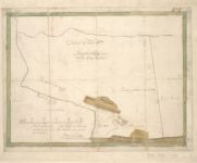
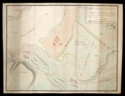
| Title: | A plan of the Grounds Adjacent to Fort William | |
| Survey: | 1748 | |
| Shelfmark: | Acc.3572 | |
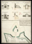
| Title: | Plan, Elevation and Section of the South Bastion of Fort William, Shewing the Breach occasiond by the Shooting of Part of the Scarp-Wall. | |
| Name: | Walker, Thomas (Engineer) | |
| Survey: | 1751 | |
| Shelfmark: | MS.1646 Z.02/31a | |
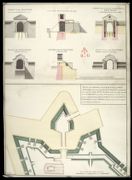
| Title: | Plan, Elevation and Section of the South Bastion of Fort William, Shewing the Breach occasion'd by the Shooting of Part of the Scarp Wall [copy] | |
| Name: | Walker, Thomas (Engineer) Gould, Francis (Draughtsman) | |
| Survey: | [1751] | |
| Shelfmark: | MS.1646 Z.02/31b | |
| Title: | Sketch of the Ground in the Neighbourhood of Fort William, in the Shire of Inverness, and the Point of Corpach. | |
| Name: | [Frazer, Andrew (Engineer)] | |
| Survey: | Post-1780 | |
| Shelfmark: | MS.1649 Z.03/46 | |
| Title: | Sketch of the Ground in the Neighbourhood of Fort William (in the Shire of Inverness) and the Point of Corpach [copy] | |
| Name: | Parish, Henry W. (Draughtsman) | |
| Survey: | 1782 | |
| Shelfmark: | MS.1650 Z.46/20 | |
| Title: | [Map of area around Fort William showing] Boundary of the Crown lands; plans, elevations and sections of Ordnance Store and Magazine; Table of Reference [showing] Nature of the Encroachment, How Occupied, Occupiers Name, and Rent & to Whom Paid | |
| Name: | Elphinstone, Sir Howard (Engineer) | |
| Survey: | 1818 | |
| Shelfmark: | MS.1650 Z.46/21 | |
| Title: | Fort William; plan shewing the situation and extent of the grant made to the Episcopal Inhabitants by the Board in Decr. 1815 | |
| Name: | Elphinstone, Sir Howard (Engineer) | |
| Survey: | 1818 | |
| Shelfmark: | MS.1650 Z.46/22 | |