Military Maps of Scotland (18th century)
Your search returned 48 records.
Ordered by maps relating to the whole county first, then alphabetically by parish.
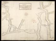
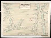
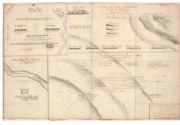
| Title: | The Roads between Innersnait Ruthvan of Badenock Kiliwhiman and Fort William in ye highlands of North Brittain | |
| Name: | Dumaresq, John & Bastide, John Henri (Engineer) Bastide, John Henri (Draughtsman) | |
| Original Survey: | 1718 | |
| Shelfmark: | MS.1648 Z.03/13a | |
| Title: | The Roads between Innersnait Ruthvan of Badenock Kiliwhiman and Fort William in the highlands of North Brittian [1718] [copy] | |
| Name: | Dumaresq, John & Bastide, John Henri (Engineer) Bastide, John Henri (Draughtsman) | |
| Original Survey: | 1718 | |
| Shelfmark: | MS.1648 Z.03/13b | |
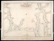
| Title: | A Map of the Roads between Innersnaid Ruthvan of Badenock, Kiliwhiman and Fort William, in the Highlands of North Brittain [1718] 1741[copy] | |
| Name: | Dumaresq, John & Bastide, John Henri (Engineer) Bastide, John Henri (Draughtsman) Coombs, Richard (Copyist) | |
| Original Survey: | 1741 | |
| Shelfmark: | MS.1648 Z.03/14a | |
| Title: | A Map of the Roads between Innersnait, Ruthvan of Badenock, Kiliwhiman and Fort William, in the Highlands of North Brittain [1718] 1741[copy] | |
| Name: | Dumaresq, John & Bastide, John Henri (Engineer) Bastide, John Henri (Draughtsman) Assiotti, Francis Aegidius (Copyist) | |
| Original Survey: | 1741 | |
| Shelfmark: | MS.1648 Z.03/14b | |
| Title: | A Map of the Roads between Innersnaid Ruthvan of Badenock, Kiliwhiman and Fort William in the Highlands of North Brittain [1718] 1741 [copy] | |
| Name: | Dumaresq, John & Bastide, John Henri (Engineer) Bastide, John Henri (Draughtsman) | |
| Original Survey: | 1741 | |
| Shelfmark: | MS.1648 Z.03/14c | |
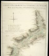
| Title: | Survey of Part of the Road from Sterling to Fort William; Made by the Party of Genl. Pultneys Regiment in 1749 | |
| Name: | Morrison, George (Engineer) | |
| Original Survey: | 1749 | |
| Shelfmark: | MS.1649 Z.03/39a | |
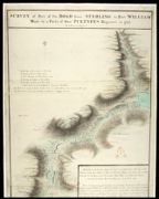
| Title: | Survey of Part of the Road from Sterling to Fort William; Made by the Party of Genl. Pultneys Regiment in 1749 [copy] | |
| Name: | Morrison, George (Engineer) | |
| Original Survey: | 1749 | |
| Shelfmark: | MS.1649 Z.03/39b | |
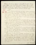
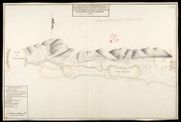
| Title: | Remarks on the Country Adjacent to part of the Road from Sterling to Fort William, made by the Party of Genl. Pultneys Regement, from part of Loch Lubinich to the beginning of Larigilay. Eight Miles and Forty five Yards | |
| Name: | Morrison, George (Engineer) | |
| Original Survey: | 1749 | |
| Shelfmark: | MS.1649 Z.03/39c | |
| Parish: | Boleskine and Abertarff, Buchanan, Kingussie, Glenelg | |
| Title: | Killewhiman, Inversnait, Ruthven of Badenoch, Bernera [copy] | |
| Name: | Jelfe, Andrews (Architect) | |
| Original Survey: | 1719 | |
| Shelfmark: | MS.1648 Z.03/18a | |
| Parish: | Boleskine and Abertarff, Buchanan, Kingussie, Glenelg | |
| Title: | Killewhiman, Inversnait, Ruthven of Badenoch, Bernera | |
| Name: | Jelfe, Andrews (Architect) | |
| Original Survey: | 1719 | |
| Shelfmark: | MS.1648 Z.03/18b | |
| Parish: | Boleskine and Abertarff, Buchanan, Kingussie, Glenelg | |
| Title: | Killewhiman, Inversnait, Ruthven of Badenoch, Bernera [draft] | |
| Name: | Jelfe, Andrews (Architect) | |
| Original Survey: | 1719 | |
| Shelfmark: | MS.1648 Z.03/18c | |
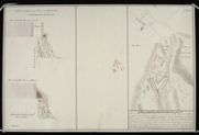
| Parish: | Buchanan | |
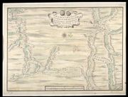
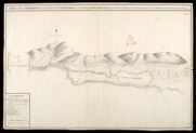
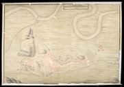
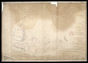
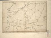
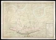
| Title: | A Draught of Innersnait, in the Highlands of North Brittain, nere the Head of Loch Lomend with part of the country adjacent [copy] | |
| Name: | Dumaresq, John & Bastide, John Henri (Engineer) Bastide, John Henri (Draughtsman) | |
| Original Survey: | [1718] | |
| Shelfmark: | MS.1648 Z.03/15a | |
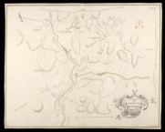
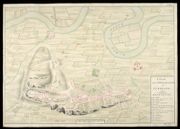
| Parish: | Buchanan | |
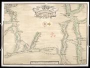
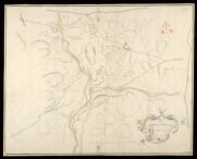
| Title: | A Draught of Innersnait, in the Highlands of North Brittain, nere the Head of Loch Lomend with part of the country adjacent | |
| Name: | Dumaresq, John & Bastide, John Henri (Engineer) Bastide, John Henri (Draughtsman) | |
| Original Survey: | 1719 | |
| Shelfmark: | MS.1648 Z.03/15b | |
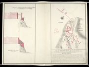
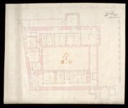
| Parish: | Buchanan | |
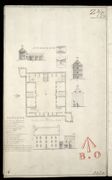
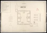
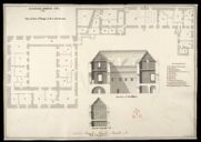
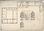
| Title: | A Plan of the Barrack at Inversnait Anno 1719 [copy] | |
| Name: | Jelfe, Andrews (Architect) | |
| Original Survey: | 1719 | |
| Shelfmark: | MS.1648 Z.03/16c | |
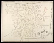
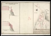
| Parish: | Buchanan | |
| Title: | Innersnait [draft] | |
| Name: | Jelfe, Andrews (Architect) | |
| Original Survey: | [1719] | |
| Shelfmark: | MS.1648 Z.03/17a | |
| Parish: | Buchanan | |
| Title: | Innersnait | |
| Name: | Jelfe, Andrews (Architect) | |
| Original Survey: | [1719] | |
| Shelfmark: | MS.1648 Z.03/17b | |
| Parish: | Buchanan | |
| Title: | Innersnait | |
| Name: | Jelfe, Andrews (Architect) | |
| Original Survey: | [1719] | |
| Shelfmark: | MS.1648 Z.03/17c | |
| Parish: | Buchanan | |
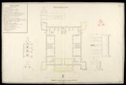
| Title: | A Plan of the Barrack at Inversnait Anno 1719 | |
| Name: | Jelfe, Andrews (Architect) | |
| Original Survey: | 1719 | |
| Shelfmark: | MS.1648 Z.03/16a | |
| Parish: | Buchanan | |
| Title: | A Plan of the Barrack at Inversnait 1719 [copied in] Anno 1725 | |
| Name: | Jelfe, Andrews (Architect) | |
| Original Survey: | 1725 | |
| Shelfmark: | MS.1648 Z.03/16b | |
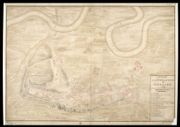
| Parish: | Buchanan | |
| Title: | A Draught of Innersnait, in the Highlands of North Brittain, nere the Head of Loch Lomend with part of the country adjacent [copy] | |
| Name: | Dumaresq, John & Bastide, John Henri (Engineer) Bastide, John Henri (Draughtsman) | |
| Original Survey: | 1742 | |
| Shelfmark: | MS.1648 Z.03/15c | |
| Parish: | Buchannan | |
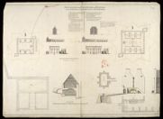
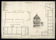
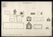
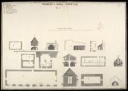
| Title: | Plan, Section and Elevation of the Barrack at Inveersnait and Kiliwhiman [with] Explanation; Powder Magasine at Edinbgh. Castle and Section of the Same at x; with a project of Arching the second Floor at y | |
| Name: | Romer, John Lambertus (Engineer) | |
| Original Survey: | [1719] | |
| Shelfmark: | MS.1647 Z.03/11a | |
| Parish: | Buchannan | |
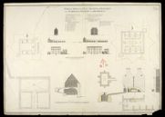
| Title: | Plan, Section and Elevation of the Barrack at Inveersnait and Kiliwhiman [with] Explanation; Powder Magasine at Edinbgh. Castle and Section of the Same at x; with a project of Arching the second Floor at y [1720] [copy] | |
| Name: | Romer, John Lambertus (Engineer) Chamberlaine, Thomas (Draughtsman) | |
| Original Survey: | 1798 | |
| Shelfmark: | MS.1647 Z.03/11b | |
| Parish: | Falkirk | |
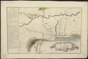
| Title: | A plan of the battle near Falkirk, Friday 17th Janr. 1746. | |
| Original Survey: | 1746 | |
| Shelfmark: | EMS.s.160 | |
| Parish: | Falkirk | |
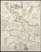
| Title: | A Map of the River Forth, from Stirling to Barroustouness, including Linlithgow, Falkirk, and the countries adjacent, with the route of both armies to the field of battle. / T. Jefferys sculp.. | |
| Name: | Jefferys, Thomas | |
| Original Survey: | 1746 | |
| Shelfmark: | EMS.s.161 | |
| Parish: | Falkirk ; Gladsmuir | |
| Title: | Battle of Preston: - September 1745. (A plan of the victory of Falkirk Muir fought the afternoon of January 16 [sic, ie. 17th] 1746. - Battle of Clifton Muir, Westmorland. 18th December 1745). | |
| Original Survey: | ca. 1746 | |
| Shelfmark: | EMS.s.164 | |
| Parish: | Stirling | |
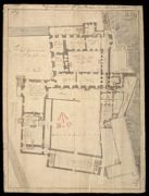
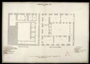
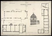
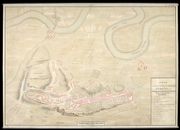
| Title: | A Plan of Sterling Castle, as here Colour'd in Red lines, and the Black is a Design for better Fortifying the Entrance of the same; A profile of Elphinstons Tower and French Spur at Sterling Castle | |
| Name: | Dury, Theodore (Engineer) Edwards, Talbot (Engineer) | |
| Original Survey: | 1708 | |
| Shelfmark: | MS.1646 Z.02/23a | |
| Parish: | Stirling | |
| Title: | A Plan of Sterling Castle, as here Color'd in Red lines, and the Black is a Design for better Fortifying the Entrance of the same; A profile of Elphinstons Tower and French Spur at Sterling Castle [1708] [copy] | |
| Name: | Dury, Theodore (Engineer) Edwards, Talbot (Engineer) Beaumont, John (Copyist) | |
| Original Survey: | [1708] | |
| Shelfmark: | MS.1646 Z.02/23b | |
| Parish: | Stirling | |
| Title: | A Plan of Sterling Castle, as here Color'd in Red lines, and the Black is a Design for better Fortifying the Entrance of the same; A profile of Elphinstons Tower and French Spur at Sterling Castle [1708] [copy] | |
| Name: | Dury, Theodore (Engineer) Edwards, Talbot (Engineer) | |
| Original Survey: | [1708?] | |
| Shelfmark: | MS.1646 Z.02/23c | |
| Parish: | Stirling | |
| Title: | Sterling Castle | |
| Name: | Dury, Theodore (Engineer) | |
| Original Survey: | [1708] | |
| Shelfmark: | MS.1646 Z.02/16a | |
| Parish: | Stirling | |
| Title: | [Stirling Castle, showing plans to fortify the main entrance and the nether bailey] | |
| Name: | Dury, Theodore (Engineer) | |
| Original Survey: | [1708?] | |
| Shelfmark: | MS.1646 Z.02/16b | |
| Parish: | Stirling | |
| Title: | Ground Floor of the Palace at Stirling Castle | |
| Name: | Dury, Theodore (Engineer) | |
| Original Survey: | [1708] | |
| Shelfmark: | MS.1646 Z.02/17 | |
| Parish: | Stirling | |
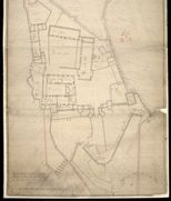
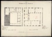
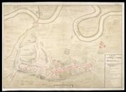
| Title: | A Plan of the Town and Castle of Stirling 1740 | |
| Original Survey: | pre-1708 survey. Map copied 1740. | |
| Shelfmark: | MS.1646 Z.02/20a | |
| Parish: | Stirling | |
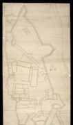
| Title: | Town and Castle of Stirling. | |
| Original Survey: | pre-1708 survey. | |
| Shelfmark: | MS.1646 Z.02/20b | |
| Parish: | Stirling | |
| Title: | Sterling Castle, No. 1, [copy] 1741 | |
| Name: | Jelfe, Andrews (Architect) Moore, Thomas (Engineer) | |
| Original Survey: | [1719] | |
| Shelfmark: | MS.1646 Z.02/22a | |
| Parish: | Stirling | |
| Title: | Sterling Castle, No. 2, [copy] 1741 | |
| Name: | Jelfe, Andrews (Architect) Moore, Thomas (Engineer) | |
| Original Survey: | [1719] | |
| Shelfmark: | MS.1646 Z.02/22b | |
| Parish: | Stirling | |
| Title: | Sterling Castle, No. 3, [copy] 1741 | |
| Name: | Jelfe, Andrews (Architect) Moore, Thomas (Engineer) | |
| Original Survey: | [1719] | |
| Shelfmark: | MS.1646 Z.02/22c | |
| Parish: | Stirling | |
| Title: | Sterling Castle, No. 4 [copy 1741] | |
| Name: | Jelfe, Andrews (Architect) Moore, Thomas (Engineer) | |
| Original Survey: | [1719] | |
| Shelfmark: | MS.1646 Z.02/22d | |
| Parish: | Stirling | |
| Title: | Sterling Castle, November 1719. No.1: Plan of the 3d Stage at A in the Section | |
| Name: | Jelfe, Andrews (Architect) Moore, Thomas (Engineer) | |
| Original Survey: | 1719 | |
| Shelfmark: | MS.1646 Z.02/18a | |
| Parish: | Stirling | |
| Title: | Sterling Castle, [November] 1719, No.2 | |
| Name: | Jelfe, Andrews (Architect) Moore, Thomas (Engineer) | |
| Original Survey: | 1719 | |
| Shelfmark: | MS.1646 Z.02/18b | |
| Parish: | Stirling | |
| Title: | Sterling Castle, Novemr 1719, No.3 | |
| Name: | Jelfe, Andrews (Architect) Moore, Thomas (Engineer) | |
| Original Survey: | 1719 | |
| Shelfmark: | MS.1646 Z.02/18c | |
| Parish: | Stirling | |
| Title: | Sterling Castle, Novembr: 1719, No.4 | |
| Name: | Jelfe, Andrews (Architect) Moore, Thomas (Engineer) | |
| Original Survey: | 1719 | |
| Shelfmark: | MS.1646 Z.02/18d | |
| Parish: | Stirling | |
| Title: | [Map showing the intended military roads joining up Stirling with Fort Augustus, etc.] | |
| Name: | [Wade, George (Engineer)] | |
| Original Survey: | [ca. 1724-45?] | |
| Shelfmark: | Acc.10497 Wade.58e | |
| Parish: | Stirling | |
| Title: | A Plan of the Town and Castle of Sterling 1725 | |
| Name: | Laye, John (Copyist) | |
| Original Survey: | 1725 | |
| Shelfmark: | MS.1646 Z.02/19a | |
| Parish: | Stirling | |
| Title: | A Plan of the Town and Castle of Sterling 1725 | |
| Original Survey: | 1725 | |
| Shelfmark: | MS.1646 Z.02/19b | |
| Parish: | Stirling | |
| Title: | Plan of the Town and Castle of Sterling 1740 | |
| Original Survey: | [1725] | |
| Shelfmark: | MS.1646 Z.02/21a | |
| Parish: | Stirling | |
| Title: | A Plan of the Town and Castle of Sterling 1740 [copy] | |
| Name: | Chamberlaine, Augustus H. (Copyist) | |
| Original Survey: | [1725] | |
| Shelfmark: | MS.1646 Z.02/21b | |
| Parish: | Stirling | |
| Title: | A Plan of the Town and Castle of Sterling 1740 | |
| Original Survey: | [1725] | |
| Shelfmark: | MS.1646 Z.02/21c | |
| Parish: | Stirling | |
| Title: | Plan of the Governor's appartments at Stirling Castle | |
| Original Survey: | 1733 | |
| Shelfmark: | MS.1649 Z.46/58 | |