Military Maps of Scotland (18th century)
Your search returned 211 records.
Ordered by maps relating to the whole county first, then alphabetically by parish.
| Title: | View Map | |
| Shelfmark: | Adv.MS.16.1.20 | |
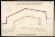
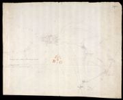
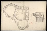
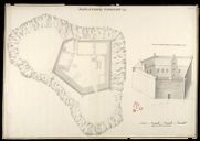
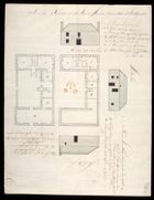
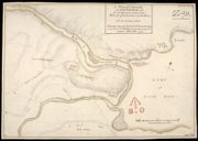
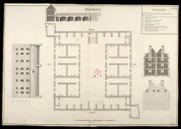
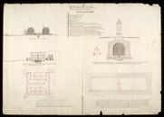
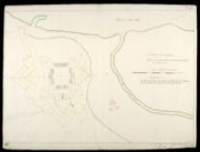
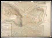
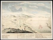
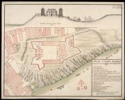
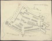
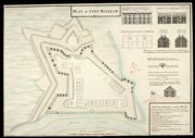
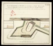
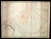
| Title: | [Plan of Fort] | |
| Name: | [Wade, George (Engineer)] | |
| Original Survey: | [ca. 1724-45?] | |
| Shelfmark: | Acc.10497 Wade.58k | |
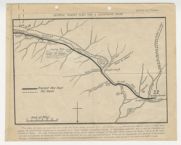
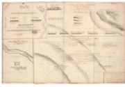
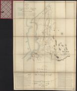
| Title: | [Sketch and description of the proposed Roads from Callander and Loch Tay to Fort William and Appin including details of mileage and of inns] | |
| Name: | [Wade, George (Engineer)] | |
| Original Survey: | [ca. 1724-45?] | |
| Shelfmark: | Acc.10497 Wade.58m | |
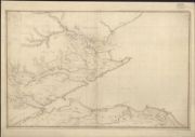
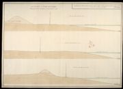
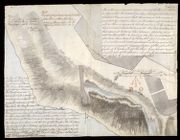
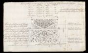
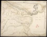
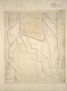
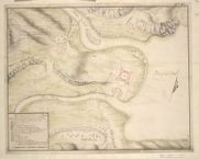
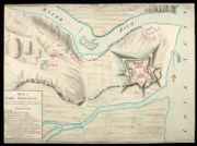
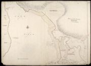
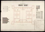
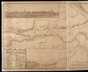
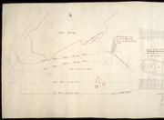
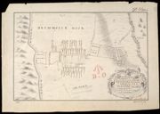
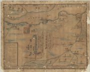
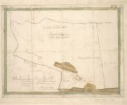
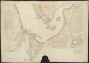
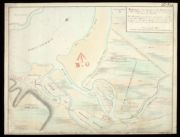
| Title: | This Plan containing Lochness Lochoyoch, Lochlochey, & all the Rivers and Strips of water that Runs in & set out from the same, from the East Sea before Inverness to the West Sea at Inverlochey before Fort William, together with all Roads & Remarkable pla | |
| Name: | Avery, Joseph | |
| Original Survey: | [ca.1727] | |
| Shelfmark: | MS.1648 Z.03/21 | |
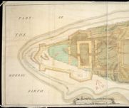
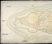
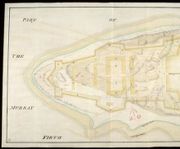
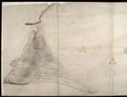
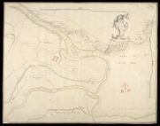
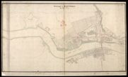
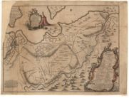
| Title: | [Plan of the Murray Firth and Cromarty Firth, with parts of the Shires of Inverness, Sutherland, Ross, Nairn, and Elgin. Showing roads] | |
| Name: | [Avery, Joseph Wade, George (Engineer)] | |
| Original Survey: | 1730 | |
| Shelfmark: | Acc.10497 Wade.58d | |
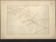
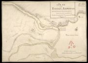
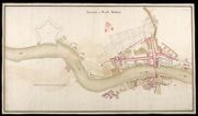
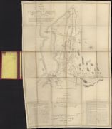
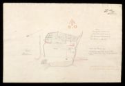
| Title: | A Plan of the Country where the New Intended Road is to be made from the Barrack at Ruthven in Badenoth to Invercall in Brae Marr… | |
| Name: | Avery, Joseph (Engineer) [Wade, George (Engineer)] | |
| Original Survey: | 1735 | |
| Shelfmark: | Acc.10497 Wade.58b | |
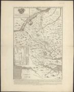
| Title: | An exact plan of His Majesty's great roads through the Highlands of Scotland / (Ad: Rutherfurd delin. C. Mosley sculp.). | |
| Name: | Rutherfurd, Andrew. | |
| Original Survey: | 1745 | |
| Shelfmark: | EMS.s.90b | |
| Title: | An exact plan of His Majesty's great roads through the Highlands of Scotland | |
| Original Survey: | 1746 | |
| Shelfmark: | Newman 1152(1) | |
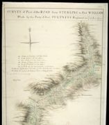
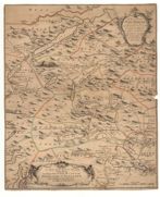
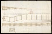
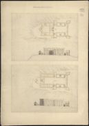
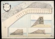
| Title: | Survey of Part of the Road from Sterling to Fort William; Made by the Party of Genl. Pultneys Regiment in 1749 | |
| Name: | Morrison, George (Engineer) | |
| Original Survey: | 1749 | |
| Shelfmark: | MS.1649 Z.03/39a | |
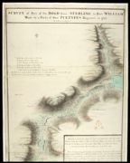
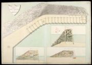
| Title: | Survey of Part of the Road from Sterling to Fort William; Made by the Party of Genl. Pultneys Regiment in 1749 [copy] | |
| Name: | Morrison, George (Engineer) | |
| Original Survey: | 1749 | |
| Shelfmark: | MS.1649 Z.03/39b | |
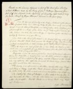
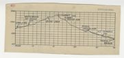
| Title: | Remarks on the Country Adjacent to part of the Road from Sterling to Fort William, made by the Party of Genl. Pultneys Regement, from part of Loch Lubinich to the beginning of Larigilay. Eight Miles and Forty five Yards | |
| Name: | Morrison, George (Engineer) | |
| Original Survey: | 1749 | |
| Shelfmark: | MS.1649 Z.03/39c | |
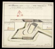
| Title: | A Survey of the Road made by the Detatchments Colln. Rich's & Genl. Guise's Regts. between Fort William & the head of King-loch Leven 1750 | |
| Name: | Archer, John (Engineer) | |
| Original Survey: | 1750 | |
| Shelfmark: | MS.1649 Z.03/40a | |
| Title: | General Wade's plan for a Glenfeshie road. | |
| Name: | Avery, Joseph / Mathieson, John | |
| Original Survey: | 1923 | |
| Shelfmark: | EMS.b.2.174(24) | |
| Title: | [Profile of the proposed route of Wade's road from Linn of Dee via Geldie Lodge and Glen Feshie to Tromie Bridge] | |
| Name: | Avery, Joseph / Mathieson, John | |
| Original Survey: | 1923 | |
| Shelfmark: | EMS.b.2.174(24) | |
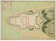
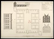
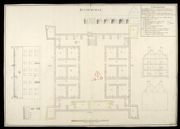
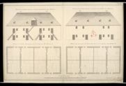
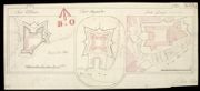
| Parish: | Ardersier | |
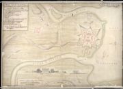
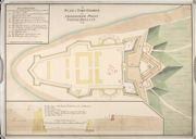
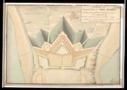
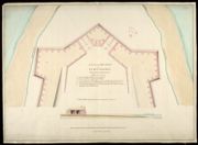
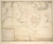
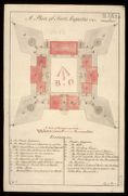
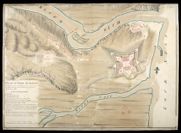
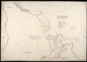
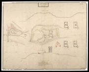
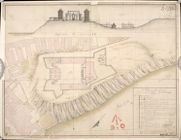
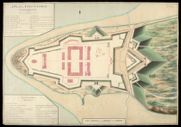
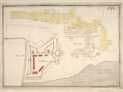
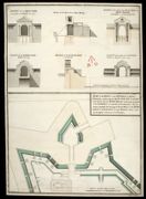
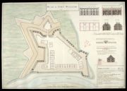
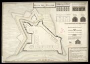
| Title: | A Plan of Fort Augustus with the Old Barracks and Situation 1734 | |
| Original Survey: | 1734 | |
| Shelfmark: | MS.1647 Z.02/61a | |
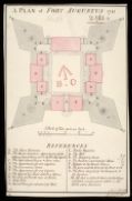
| Parish: | Ardersier | |
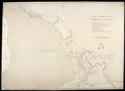
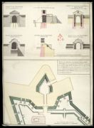
| Title: | A Plan of Fort Augustus with the Old Barracks and Situation 1734 [copy] | |
| Name: | Hewitt, John (Copyist) | |
| Original Survey: | 1734 | |
| Shelfmark: | MS.1647 Z.02/61b | |
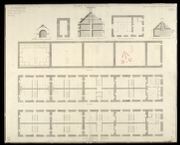
| Parish: | Ardersier | |
| Title: | Plan of the point of land at Arderseer with the design'd fort as trac'd thereon | |
| Name: | Skinner, William (Engineer) Heath, Joseph (Draughtsman) | |
| Original Survey: | [ca.1748-9?] | |
| Shelfmark: | MS.1647 Z.02/57a | |
| Parish: | Ardersier | |
| Title: | Plan of the point of land at Arderseer with the design'd fort as trac'd thereon [copy] | |
| Name: | Skinner, William (Engineer) Heath, Joseph (Draughtsman) | |
| Original Survey: | [ca.1748-9?] | |
| Shelfmark: | MS.1647 Z.02/57b | |
| Parish: | Ardersier | |
| Title: | Plan of the point of land at Arderseer with the design'd Fort as trac'd thereon [copy] | |
| Name: | Skinner, William (Engineer) Heath, Joseph (Draughtsman) | |
| Original Survey: | [ca.1748-9?] | |
| Shelfmark: | MS.1647 Z.02/57c | |
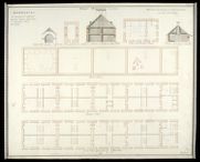
| Parish: | Ardersier | |
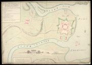
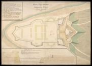
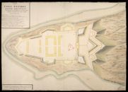
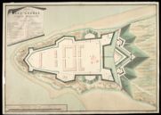
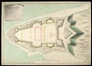
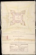
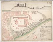
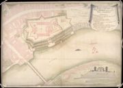
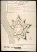
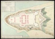
| Title: | A Plan of Fort George on Arderseer Point North Britain 1749 | |
| Name: | Skinner, William (Engineer) | |
| Original Survey: | 1749 | |
| Shelfmark: | MS.1646 Z.02/39a | |
| Parish: | Ardersier | |
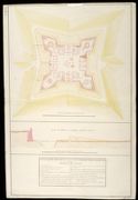
| Title: | A Plan of Fort George on Arderseer Point North Britain 1749 [copy] | |
| Name: | Skinner, William (Engineer) | |
| Original Survey: | 1749 | |
| Shelfmark: | MS.1646 Z.02/39b | |
| Parish: | Ardersier | |
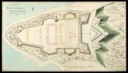
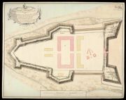
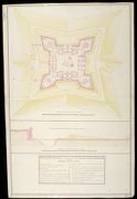
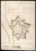
| Title: | Plan of Fort George North Brittain Shewing how far the Works are Carried on in 1750 and what is propos'd to be done in 1751. | |
| Name: | Skinner, William (Engineer) Tarrant, Charles (Draughtsman) | |
| Original Survey: | 1750 | |
| Shelfmark: | MS.1646 Z.02/40a | |
| Parish: | Ardersier | |
| Title: | Plan of Fort George North Britain Shewing how far the Works are Carried on in 1750 and what is propos'd to be done in 1751 [copy] | |
| Name: | Skinner, William (Engineer) Tarrant, Charles (Draughtsman) Day, Thomas (Copyist) | |
| Original Survey: | 1750 | |
| Shelfmark: | MS.1646 Z.02/40b | |
| Parish: | Ardersier | |
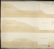
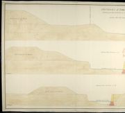
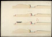
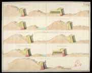
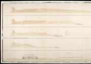
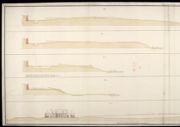
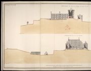
| Title: | Sections of Fort George Shewing how far the Works are Executed in 1750; Section thro' the Line 1.2; Section thro' the Line 3.4; Section thro' the Line 5.6 | |
| Name: | Skinner, William (Engineer) Tarrant, Charles (Draughtsman) | |
| Original Survey: | 1750 | |
| Shelfmark: | MS.1646 Z.02/41a | |
| Parish: | Ardersier | |
| Title: | Sections of Fort George Shewing how far the Works are Executed in 1750; Section thro' the Line 1.2; Section thro' the Line 3.4; Section thro' the Line 5.6 [copy] | |
| Name: | Skinner, William (Engineer) Tarrant, Charles (Draughtsman) | |
| Original Survey: | 1750 | |
| Shelfmark: | MS.1646 Z.02/41b | |
| Parish: | Ardersier | |
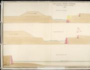
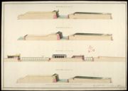
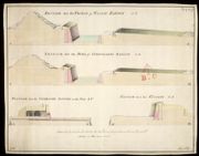
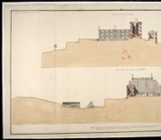
| Title: | Sections of Fort George Shewing how far the Works are Executed in 1750; Section thro' the Line 7.8; Section thro' the Line 9.10; Section thro' the Line 11.12 | |
| Name: | Skinner, William (Engineer) Tarrant, Charles (Draughtsman) | |
| Original Survey: | 1750 | |
| Shelfmark: | MS.1646 Z.02/42a | |
| Parish: | Ardersier | |
| Title: | Sections of Fort George Shewing how far the Works are Executed in 1750; Section thro' the Line 7.8; Section thro' the Line 9.10; Section thro' the Line 11.12 [copy] | |
| Name: | Skinner, William (Engineer) Tarrant, Charles (Draughtsman) | |
| Original Survey: | 1750 | |
| Shelfmark: | MS.1646 Z.02/42b | |
| Parish: | Ardersier | |
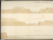
| Title: | Sections of Fort George Shewing how far the Works are Executed in 1750; Section thro' the Line 13.14; Section thro' the Line 15.16; Section thro' the Line 17.18. | |
| Name: | Skinner, William (Engineer) Tarrant, Charles (Draughtsman) | |
| Original Survey: | 1750 | |
| Shelfmark: | MS.1646 Z.02/43a | |
| Parish: | Ardersier | |
| Title: | Sections of Fort George Shewing how far the Works are Executed in 1750; Section thro' the Line 13.14; Section thro' the Line 15.16; Section thro' the Line 17.18. [copy] | |
| Name: | Skinner, William (Engineer) Tarrant, Charles (Draughtsman) | |
| Original Survey: | 1750 | |
| Shelfmark: | MS.1646 Z.02/43b | |
| Parish: | Ardersier | |
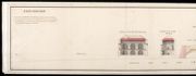
| Title: | A Plan of the Principal Front of Fort George Shewing how far the Works are Carried on to the 30th. September 1751 | |
| Name: | Skinner, William (Engineer) Tarrant, Charles (Draughtsman) | |
| Original Survey: | 1751 | |
| Shelfmark: | MS.1646 Z.02/44 | |
| Parish: | Ardersier | |
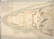
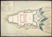
| Title: | A Plan of Fort George North Britain 1752 | |
| Name: | Skinner, William (Engineer) | |
| Original Survey: | 1752 | |
| Shelfmark: | MS.1646 Z.02/45a | |
| Parish: | Ardersier | |
| Title: | A Plan of Fort George North Britain 1752 [copy] | |
| Name: | Skinner, William (Engineer) | |
| Original Survey: | 1752 | |
| Shelfmark: | MS.1646 Z.02/45b | |
| Parish: | Ardersier | |
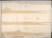
| Title: | [Fort George, North Britain, 1752] Section thro' line 9.10 on the plan; section on the Line 11.12 on the Plan; Section on the Line 13.14 on the Plan; Section on the Line 15, 16 on the Plan | |
| Name: | Skinner, William (Engineer) | |
| Original Survey: | [1752] | |
| Shelfmark: | MS.1646 Z.02/45c | |
| Parish: | Ardersier | |
| Title: | [Fort George, North Britain, 1752] Section thro' the Line 9.10 on the Plan; Section on the Line 11.12 on the Plan; Section on the Line 13.14 on the Plan; Section on the Line 15, 16, on the Plan [copy] | |
| Name: | Skinner, William (Engineer) | |
| Original Survey: | [1752] | |
| Shelfmark: | MS.1646 Z.02/45d | |
| Parish: | Ardersier | |
| Title: | Fort George [North Britain] No.5; Section thro' the Line i.k; Section thro' the Line l.m; Section thro' the Line n.o; Section thro' the Line p.q | |
| Name: | Skinner, William (Engineer) Tarrant, Charles (Draughtsman) | |
| Original Survey: | 1752 | |
| Shelfmark: | MS.1646 Z.02/46a | |

| Parish: | Ardersier | |
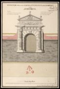
| Title: | [Fort George, North Britain 1752,] No. 4; Section thro' the Gateway, Bridge, and Coverd-Way; Plan of the Bridge and Gateway to the Ravelin; Elevation of the Front of the Gateway. | |
| Name: | Skinner, William (Engineer) Tarrant, Charles (Draughtsman) | |
| Original Survey: | 1752 | |
| Shelfmark: | MS.1646 Z.02/46b | |
| Parish: | Ardersier | |
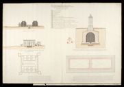
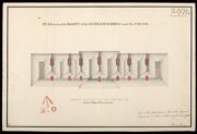
| Title: | Plan Elevation and Section of the Guard House in the Ravelin at Fort George, 1752; No.3 | |
| Name: | Skinner, William (Engineer) Tarrant, Charles (Draughtsman) | |
| Original Survey: | 1752 | |
| Shelfmark: | MS.1646 Z.02/47a | |
| Parish: | Ardersier | |
| Title: | [Fort George North Britain 1752] No.2; section thro' the Line a.b on the Plan; Section thro' the Line c.d; Section thro' the Line e.f; Section thro' the Line g.h | |
| Name: | Skinner, William (Engineer) Tarrant, Charles (Draughtsman) | |
| Original Survey: | 1752 | |
| Shelfmark: | MS.1646 Z.02/47b | |
| Parish: | Ardersier | |
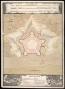
| Title: | A Plan of Fort George, North Britain, shewing how far executed 1753 | |
| Name: | Skinner, William (Engineer) Tarrant, Charles (Draughtsman) | |
| Original Survey: | 1753 | |
| Shelfmark: | MS.1646 Z.02/48a | |
| Parish: | Ardersier | |
| Title: | A Plan of Fort George North Britain Shewing how far Executed 1753 [copy] | |
| Name: | Skinner, William (Engineer) | |
| Original Survey: | 1753 | |
| Shelfmark: | MS.1646 Z.02/48b | |
| Parish: | Ardersier | |
| Title: | [Fort George North Britain, 1753]; Section thro' the Line 1.2; Section thro' the Line 3.4; Section thro' the Line 5.6.7; Section thro' the Line 8.9 | |
| Name: | Skinner, William (Engineer) Tarrant, Charles (Draughtsman) | |
| Original Survey: | 1753 | |
| Shelfmark: | MS.1646 Z.02/48c | |
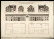
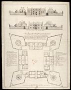
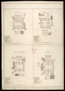
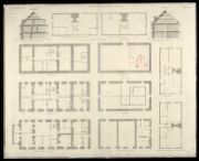
| Parish: | Ardersier | |
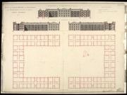
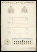
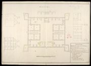
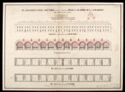
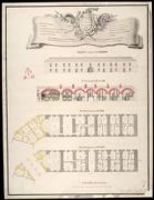
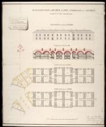
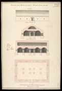
| Title: | Plan and Elevations with Sections of the Barracks for 1600 Men and Officers Fort George 1753 | |
| Name: | Skinner, William (Engineer) Tarrant, Charles (Draughtsman) | |
| Original Survey: | 1753 | |
| Shelfmark: | MS.1646 Z.02/50a | |
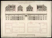
| Parish: | Ardersier | |
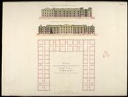
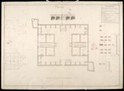
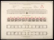
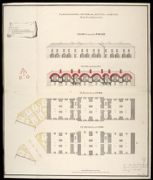
| Title: | Plan Elevations and Sections of the North Pile of Barracks Shewing how High they were rais'd in the Year 1754 | |
| Name: | Skinner, William (Engineer) | |
| Original Survey: | 1754 | |
| Shelfmark: | MS.1646 Z.02/50b | |
| Parish: | Ardersier | |
| Title: | A Plan of the West Front of Fort George, Commanding the Channel; Section thro the South Casmate marked FG | |
| Name: | Skinner, William (Engineer) | |
| Original Survey: | 1754 | |
| Shelfmark: | MS.1647 Z.02/53 | |
| Parish: | Ardersier | |
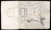
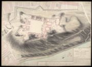
| Title: | Plan of Fort George Shewing how far the Works were Carried on in the Year 1754 | |
| Name: | Skinner, William (Engineer) Tarrant, Charles (Draughtsman) | |
| Original Survey: | 1754 | |
| Shelfmark: | MS.1646 Z.02/49a | |
| Parish: | Ardersier | |
| Title: | [Plan of Fort George 1754] Section thro' the Line 1.2; Section thro' the Line 3.4; Section thro' the Line 5.6; Section thro' the Line 7.8; Section thro' the Line 9.10; Section thro' the Line 11.12; Section thro' the Line 13.14; Section thro' the Line 15.1 | |
| Name: | Skinner, William (Engineer) Tarrant, Charles (Draughtsman) | |
| Original Survey: | 1754 | |
| Shelfmark: | MS.1646 Z.02/49b | |
| Parish: | Ardersier | |
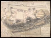
| Title: | A Plan of Fort George Shewing the State of the Works 30 Sepr. 1756 | |
| Name: | Skinner, William (Engineer) | |
| Original Survey: | 1756 | |
| Shelfmark: | MS.1646 Z.02/51a | |
| Parish: | Ardersier | |
| Title: | [A Plan of Fort George 30 Sepr. 1756]; Section thro' the Prince of Wales's Bastion A B; Section thro' the Duke of Cumberlands Bastion CD; Section thro' the Casemated Battery on the Point E F; Section thro' the Curtain G H | |
| Name: | Skinner, William (Engineer) | |
| Original Survey: | 1756 | |
| Shelfmark: | MS.1646 Z.02/51b | |
| Parish: | Ardersier | |
| Title: | Plan of the Fountations of Prince Henry Fredericks Bastion with the proposed Sheds for Carpenters, Smiths and Wheelwrights Shops with Room for Shott Pounds for Shott and Shells 1762 | |
| Name: | Skinner, William (Engineer) | |
| Original Survey: | 1762 | |
| Shelfmark: | MS.1647 Z.02/54a | |
| Parish: | Ardersier | |
| Title: | Plan of the Foundations of Prince Henry Fredericks Bastion with the proposed Sheds for Carpenters, Smiths and Wheelwrights Shops with Room for Shott Pounds for Shott and Shells 1762 [copy] | |
| Name: | Skinner, William (Engineer) | |
| Original Survey: | 1762 | |
| Shelfmark: | MS.1647 Z.02/54b | |
| Parish: | Ardersier | |
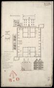
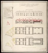
| Title: | Plan Elevation and Sections of the Store-House for Provisions, and Barrack-Masters Stores 1762 | |
| Name: | Skinner, William (Engineer) | |
| Original Survey: | 1762 | |
| Shelfmark: | MS.1647 Z.02/55a | |
| Parish: | Ardersier | |
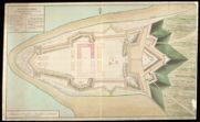
| Title: | A plan of Fort George North Britain Design[e]d & exec[ute]d by Skinner, Chief Engineer | |
| Original Survey: | 1763 | |
| Shelfmark: | EMS.s.801 | |
| Parish: | Ardersier | |
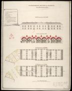
| Title: | Plan Elevation and Sections of the Store-House for Provisions, and Barrack-Masters Stores 1762 [copy] | |
| Name: | Skinner, William (Engineer) Booth, William (Draughtsman) | |
| Original Survey: | 1764 | |
| Shelfmark: | MS.1647 Z.02/55b | |
| Parish: | Ardersier | |
| Title: | Plans, Elevations, and Sections of the North Ordnance Store-House at Fort George with a Design for converting part of the North end of the said Building into an Hospital, for the better accomodation of the Troops | |
| Name: | Rudyard, Henry (Engineer) | |
| Shelfmark: | MS.1649 Z.03/50 | |
| Parish: | Ardersier | |
| Title: | [Shore at Fort George showing tides] [copy] | |
| Name: | Frazer Andrew (Engineer) | |
| Original Survey: | 1785 | |
| Shelfmark: | MS.1650 Z.46/57h | |
| Parish: | Ardersier | |
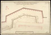
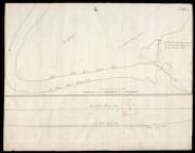
| Title: | Sketch of the Ground about Fort George | |
| Name: | Frazer, Andrew (Engineer) | |
| Original Survey: | 1785? | |
| Shelfmark: | MS.1646 Z.02/35b | |
| Parish: | Ardersier | |
| Title: | Outline of the East End of Fort George with References to the Estimate for Works & Repairs proposed for that place, in the year 1787. | |
| Name: | Shipley, Sir Charles (Engineer) | |
| Original Survey: | 1787 | |
| Shelfmark: | MS.1650 Z.46/57i | |
| Parish: | Ardersier | |
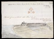
| Title: | Sketch from without the Pier head; Opposite Prince William Henry's Bastion, Fort George, North Britain | |
| Name: | Shipley, Sir Charles (Engineer) | |
| Original Survey: | 1787 | |
| Shelfmark: | MS.1650 Z.46/57a | |
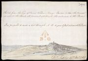
| Parish: | Ardersier | |
| Title: | Sketch from the Face of Prince William Henrys Bastion, to Shew the Manner in which the Bank at present obstructs the entrance to the bason [Fort George, Ardersier] | |
| Name: | Shipley, Sir Charles (Engineer) | |
| Original Survey: | 1787 | |
| Shelfmark: | MS.1650 Z.46/57b | |
| Parish: | Ardersier | |
| Title: | A Proposed Prolongation of the Pier head, by a single row of Piles, & Planking, to be drove with the same Slope, as the Pier Viz: one foot in five [Fort George Ardersier] | |
| Name: | Shipley, Sir Charles (Engineer) | |
| Original Survey: | [1787] | |
| Shelfmark: | MS.1650 Z.46/57c | |
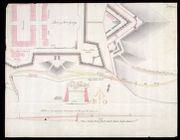
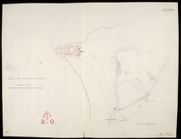
| Parish: | Ardersier | |
| Title: | [Plan of Fort George, Ardersier, showing] Present Road leadng Through the Gancion [and] Proposed Road to the Ferry | |
| Name: | Frazer Andrew (Engineer) | |
| Original Survey: | [1787] | |
| Shelfmark: | MS.1650 Z.46/57d | |
| Parish: | Ardersier | |
| Title: | [Sketch of the Ground about Fort George 1785] [copy] | |
| Name: | Frazer Andrew (Engineer) | |
| Original Survey: | [1787] | |
| Shelfmark: | MS.1650 Z.46/57e | |
| Parish: | Ardersier | |
| Title: | Sketch of the Carpenters Work in Ten Feet Running of the Pier at Fort George | |
| Name: | Shipley, Sir Charles (Engineer) Elphinstone, Sir Howard (Engineer) | |
| Original Survey: | 1787 | |
| Shelfmark: | MS.1650 Z.46/57f | |
| Parish: | Ardersier | |
| Title: | Plan of the Pier [Fort George] [copy] | |
| Name: | Frazer Andrew (Engineer) | |
| Original Survey: | [1787] | |
| Shelfmark: | MS.1650 Z.46/57g | |
| Parish: | Ardersier, Rosemarkie | |
| Title: | [Map of the Moray Firth showing Ardersier Point and Fort George, and Chanonry Point, Fortrose and Rosemarkie] | |
| Name: | Frazer, Andrew | |
| Original Survey: | 1785 | |
| Shelfmark: | MS.1650 Z.47/21 | |
| Parish: | Ardnamurchan | |
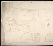
| Title: | Plann of Castle Tyrholme; Profile of Castle Tyrholme upon the Line CAB | |
| Name: | Petit, Lewis (Engineer) | |
| Original Survey: | [1714] | |
| Shelfmark: | MS.1648 Z.03/25a | |
| Parish: | Ardnamurchan | |
| Title: | Plan of Castle Tyrholme; View of Castle Tyrholme on the Sides C,A,B [copy] 1741 | |
| Name: | Petit, Lewis (Engineer) | |
| Original Survey: | 1741 | |
| Shelfmark: | MS.1648 Z.03/25b | |
| Parish: | Ardnamurchan, Torosay | |
| Title: | Plan of Castle Tyrim in Muydart; Plan of Castle Duirt in the Island of Mull 1748 [copy] | |
| Name: | Watson, David (Engineer) Sandby, Paul (Draughtsman) | |
| Original Survey: | 1748 | |
| Shelfmark: | MS.1648 Z.03/28d | |
| Parish: | Ardnamurchan, Torosay | |
| Title: | Plan of Castle Tyrim in Muydart; Plan of Castle Duirt in the Island of Mull 1748 | |
| Name: | Watson, David (Engineer) Sandby, Paul (Draughtsman) | |
| Original Survey: | 1748 | |
| Shelfmark: | MS.1648 Z.03/28e | |
| Parish: | Ardnamurchan, Torosay, Lismore & Appin | |
| Title: | Report of Castle Tyrrim, Castle Duirt and the Castle in Island Stalker | |
| Name: | Watson, David (Engineer) | |
| Original Survey: | 1748 | |
| Shelfmark: | MS.1648 Z.03/28f | |
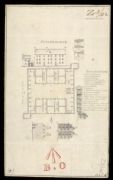
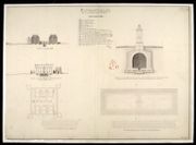
| Parish: | Boleskine and Abertarff | |
| Title: | A Plan & Elevation of Mr Stewart's House, the Barrack-master at Fort Augustus. | |
| Name: | [Clark or Carte, Thomas] [Storekeeper - name in bottom left corner] | |
| Shelfmark: | MS.1650 Z.46/59 | |
| Parish: | Boleskine and Abertarff | |
| Title: | Plan of Fort Augustus | |
| Shelfmark: | MS.1650 Z.46/23 | |
| Parish: | Boleskine and Abertarff | |
| Title: | A Plan of the Barrack at Kiliwhiman And of the Ground within the bounds of it betwixt the two Rivers & the letters AB.C | |
| Name: | Dumaresq, John & Bastide, John Henri (Engineer) Bastide, John Henri (Draughtsman) | |
| Original Survey: | 1718 | |
| Shelfmark: | MS.1647 Z.03/08a | |
| Parish: | Boleskine and Abertarff | |
| Title: | A Plan of ye Barrack at Kiliwhiman and of the Ground within the Bounds of it betwixt the Two Rivers; and the Letters A.B.C [copy] | |
| Name: | Dumaresq, John & Bastide, John Henri (Engineer) Bastide, John Henri (Draughtsman) | |
| Original Survey: | 1719 | |
| Shelfmark: | MS.1647 Z.03/08b | |
| Parish: | Boleskine and Abertarff | |
| Title: | A Plan of the Barrack at Killewhiman Anno 1719 | |
| Name: | Jelfe, Andrews (Architect) | |
| Original Survey: | 1719 | |
| Shelfmark: | MS.1647 Z.03/09a | |
| Parish: | Boleskine and Abertarff | |
| Title: | A Plan of the Barrack at Killewhiman Anno 1719 [copy] | |
| Name: | Jelfe, Andrews (Architect) | |
| Original Survey: | 1719 | |
| Shelfmark: | MS.1647 Z.03/09b | |
| Parish: | Boleskine and Abertarff | |
| Title: | Kiliwhiman [1719] [copy] | |
| Name: | Jelfe, Andrews (Architect) Minshall, Nathaniel (Draughtsman) | |
| Original Survey: | 1719 | |
| Shelfmark: | MS.1647 Z.03/10a | |
| Parish: | Boleskine and Abertarff | |
| Title: | Kiliwhiman [1719] | |
| Name: | Jelfe, Andrews (Architect) | |
| Original Survey: | 1719 | |
| Shelfmark: | MS.1647 Z.03/10b | |
| Parish: | Boleskine and Abertarff | |
| Title: | Kiliwhiman [draft] | |
| Name: | Jelfe, Andrews (Architect) | |
| Original Survey: | [1719] | |
| Shelfmark: | MS.1647 Z.03/10c | |
| Parish: | Boleskine and Abertarff | |
| Title: | Killewhiman [1719] | |
| Name: | Jelfe, Andrews (Architect) | |
| Original Survey: | 1719 | |
| Shelfmark: | MS.1647 Z.03/10d | |
| Parish: | Boleskine and Abertarff | |
| Title: | Plan Section and Elevation of the Barracks at Killiwhimen with a particular Plan and Section of the Cistern. | |
| Name: | Romer, John Lambertus (Engineer) | |
| Original Survey: | 1723 | |
| Shelfmark: | MS.1647 Z.03/12a | |
| Parish: | Boleskine and Abertarff | |
| Title: | Plan Section and Elevation of the barracks at Killiwhimen, with a particular plan and section of the cistern [1723] [copy] | |
| Name: | Romer, John Lambertus (Engineer) | |
| Original Survey: | 1723 | |
| Shelfmark: | MS.1647 Z.03/12c | |
| Parish: | Boleskine and Abertarff | |
| Title: | A Plan of Killiwhymen [Fort Augustus] … | |
| Name: | Debize, R. [Wade, George (Engineer)] | |
| Original Survey: | [ca. 1724-45?] | |
| Shelfmark: | Acc.10497 Wade.58f | |

| Parish: | Boleskine and Abertarff | |
| Title: | A plan of the Barracks of Killiwhymen and of the Ground about it... | |
| Name: | Debize, R. [Wade, George (Engineer)] | |
| Original Survey: | 10 February 1724-5 | |
| Shelfmark: | Acc.10497 Wade.58g | |
| Parish: | Boleskine and Abertarff | |
| Title: | [Plan of Fort and Barracks - Killiwhymen?] [CA thinks Ruthven] | |
| Name: | [Wade, George (Engineer)] | |
| Original Survey: | [ca. 1724-45?] | |
| Shelfmark: | Acc.10497 Wade.58n | |
| Parish: | Boleskine and Abertarff | |
| Title: | A plan of the intended Fortress with the Situation of Killiwhymen | |
| Name: | Romer, John Lambertus (Engineer) [Wade, George (Engineer)] | |
| Original Survey: | [1729?] | |
| Shelfmark: | Acc.10497 Wade.58h | |
| Parish: | Boleskine and Abertarff | |
| Title: | A Plan of Kiliwhymen where Fort Augustus is situated | |
| Name: | [Wade, George (Engineer)] | |
| Original Survey: | 1729 | |
| Shelfmark: | Acc.10497 Wade.58h | |
| Parish: | Boleskine and Abertarff | |
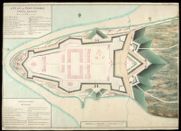
| Title: | A Plan of Fort Augustus 1741 | |
| Original Survey: | 1741 | |
| Shelfmark: | MS.1647 Z.02/62a | |
| Parish: | Boleskine and Abertarff | |
| Title: | A Plan of Fort Augustus 1741 [copy] | |
| Original Survey: | 1741 | |
| Shelfmark: | MS.1647 Z.02/62b | |
| Parish: | Boleskine and Abertarff | |
| Title: | The Plan of Fort Augustus, in the Highlands of Scotland (a modern fortification, Copied from the delineation of Captn John Romer, Engineer). This fortification was begun in 1729, & finish'd in 1742. | |
| Name: | Romer, John Lambertus (Engineer) | |
| Original Survey: | ca.1742? | |
| Shelfmark: | MS.1647 Z.02/63 | |
| Parish: | Boleskine and Abertarff | |
| Title: | A Plan of Fort Augustus With the Proposed Additional works; Expressed by the yallow lines | |
| Name: | Marcell, Lewis (Engineer) | |
| Original Survey: | 1746 | |
| Shelfmark: | MS.1647 Z.02/64a | |
| Parish: | Boleskine and Abertarff | |
| Title: | Profils of the Proposed Additional Works at Fort Augustus; Profil of the Fort through the Courtine; Profil of the Ravelin; Profil of the Covered way and Glassis; Profil through the line A.B in the Plan; Profil of the Entrenchment before the Entrance of th | |
| Name: | Marcell, Lewis (Engineer) | |
| Original Survey: | 1746 | |
| Shelfmark: | MS.1647 Z.02/64b | |
| Parish: | Boleskine and Abertarff | |
| Title: | Profils of the Proposed Additional Works at Fort Augustus [1746] [copy]; Profile of the Fort through the Courtine; Profile of the Ravelin; Profile of the Covered Way and Glacies; Profil through the Line A.B in the Plan; Profile of the Entrenchment before | |
| Name: | Marcell, Lewis (Engineer) Read, William (Copyist) | |
| Original Survey: | 1746 | |
| Shelfmark: | MS.1647 Z.02/64c | |
| Parish: | Boleskine and Abertarff | |
| Title: | The Section of One of the Principals as now design'ed for Fort Augustus; Apartments covered with a temporary Roof, and heathered consisting in all with the 2 stories above thirty four Rooms besides Vaults | |
| Name: | Marcell, Lewis (Engineer) | |
| Original Survey: | [1746] | |
| Shelfmark: | MS.1647 Z.02/64d | |
| Parish: | Boleskine and Abertarff | |
| Title: | An Estimate of the Expence for Repairing the Fortifications and Barracks Old and New at Fort Augustus; Togethar with the Expence for the Additional works to the said place | |
| Name: | Marcell, Lewis (Engineer) | |
| Original Survey: | [1746] | |
| Shelfmark: | MS.1647 Z.02/64e | |
| Parish: | Boleskine and Abertarff | |
| Title: | A Plan of Fort Augustus in its present State with a Designd Fossee & Cover'd Way [1747] | |
| Name: | Skinner, William (Engineer) | |
| Original Survey: | 1747 | |
| Shelfmark: | MS.1647 Z.02/65a | |
| Parish: | Boleskine and Abertarff | |
| Title: | A Plan of Fort Augustus in its present State with a Designd Fossee & Cover'd Way 1747 [copy] | |
| Name: | Skinner, William (Engineer) Miller, James (Copyist) | |
| Original Survey: | 1747 | |
| Shelfmark: | MS.1647 Z.02/65b | |
| Parish: | Boleskine and Abertarff | |
| Title: | A Plan of Fort Augustus in its present State with a Designd Fossee & Cover'd Way 1747 [copy] | |
| Name: | Skinner, William (Engineer) Miller, James (Copyist) | |
| Original Survey: | 1747 | |
| Shelfmark: | MS.1647 Z.02/65c | |
| Parish: | Boleskine and Abertarff | |
| Title: | A Plan of Fort Augustus shewing the repairs and Aditions done between Iune and September 1747 With the Works proposed to be Compleated in 1748 | |
| Name: | Skinner, William (Engineer) | |
| Original Survey: | 1747 | |
| Shelfmark: | MS.1647 Z.02/66a | |
| Parish: | Boleskine and Abertarff | |
| Title: | A Plan of Fort Augustus Shewing the repairs and Aditions done between Iune and September 1747 with the Works proposed to be Compleated in 1748 [copy] | |
| Name: | Skinner, William (Engineer) | |
| Original Survey: | 1747 | |
| Shelfmark: | MS.1647 Z.02/66b | |
| Parish: | Boleskine and Abertarff | |
| Title: | Plan of Fort Augustus shewing the repairs and Additions done between Iune and September 1747. with the Works proposed to be Compleated in 1748 [copy] | |
| Name: | Skinner, William (Engineer) T.C. (Copyist) | |
| Original Survey: | 1747 | |
| Shelfmark: | MS.1647 Z.02/66c | |
| Parish: | Boleskine and Abertarff | |
| Title: | [Sections of Fort Augustus 1747]; No.1, No.2, No.3, No.4 and No.5 [copy] | |
| Name: | Skinner, William (Engineer) | |
| Original Survey: | 1747 | |
| Shelfmark: | MS.1647 Z.02/70a | |
| Parish: | Boleskine and Abertarff | |
| Title: | [Sections of Fort Augustus 1747]; No.1, No.2, No.3, No.4 and No.5 | |
| Name: | Skinner, William (Engineer) | |
| Original Survey: | 1747 | |
| Shelfmark: | MS.1647 Z.02/70b | |
| Parish: | Boleskine and Abertarff | |
| Title: | A Plan of Fort Augustus with the adjacent Lands 1750 | |
| Name: | Daubant, Abraham (Engineer) | |
| Original Survey: | 1750 | |
| Shelfmark: | MS.1647 Z.02/67a | |
| Parish: | Boleskine and Abertarff | |
| Title: | A Plan of Fort Augustus with the adjacent lands 1750 [copy] | |
| Name: | Daubant, Abraham (Engineer) | |
| Original Survey: | 1750 | |
| Shelfmark: | MS.1647 Z.02/67b | |
| Parish: | Boleskine and Abertarff | |
| Title: | A Plan of Fort Augustus with the adjacent lands 1750 [copy] | |
| Name: | Daubant, Abraham (Engineer) Rogerson, William M. (Copyist) | |
| Original Survey: | 1750 | |
| Shelfmark: | MS.1647 Z.02/67c | |
| Parish: | Boleskine and Abertarff | |
| Title: | Plan and Sections of the Pier built at Fort Augustus in 1753 | |
| Name: | Skinner, William (Engineer) | |
| Original Survey: | 1753 | |
| Shelfmark: | MS.1647 Z.02/68a | |
| Parish: | Boleskine and Abertarff | |
| Title: | Plan and Section of the Pier built at Fort Augustus in 1753 [copy] | |
| Name: | Skinner, William (Engineer) Read, William (Copyist) | |
| Original Survey: | 1753 | |
| Shelfmark: | MS.1647 Z.02/68b | |
| Parish: | Boleskine and Abertarff | |
| Title: | Plan Section and Elevation of the barracks at Killiwhimen, with a particular plan and section of the cistern [1723] [copy] | |
| Name: | Romer, John Lambertus (Engineer) | |
| Original Survey: | 1766 | |
| Shelfmark: | MS.1647 Z.03/12b | |
| Parish: | Boleskine and Abertarff, Buchanan, Kingussie, Glenelg | |
| Title: | Killewhiman, Inversnait, Ruthven of Badenoch, Bernera [copy] | |
| Name: | Jelfe, Andrews (Architect) | |
| Original Survey: | 1719 | |
| Shelfmark: | MS.1648 Z.03/18a | |
| Parish: | Boleskine and Abertarff, Buchanan, Kingussie, Glenelg | |
| Title: | Killewhiman, Inversnait, Ruthven of Badenoch, Bernera | |
| Name: | Jelfe, Andrews (Architect) | |
| Original Survey: | 1719 | |
| Shelfmark: | MS.1648 Z.03/18b | |
| Parish: | Boleskine and Abertarff, Buchanan, Kingussie, Glenelg | |
| Title: | Killewhiman, Inversnait, Ruthven of Badenoch, Bernera [draft] | |
| Name: | Jelfe, Andrews (Architect) | |
| Original Survey: | 1719 | |
| Shelfmark: | MS.1648 Z.03/18c | |
| Parish: | Buchannan | |
| Title: | Plan, Section and Elevation of the Barrack at Inveersnait and Kiliwhiman [with] Explanation; Powder Magasine at Edinbgh. Castle and Section of the Same at x; with a project of Arching the second Floor at y | |
| Name: | Romer, John Lambertus (Engineer) | |
| Original Survey: | [1719] | |
| Shelfmark: | MS.1647 Z.03/11a | |
| Parish: | Buchannan | |
| Title: | Plan, Section and Elevation of the Barrack at Inveersnait and Kiliwhiman [with] Explanation; Powder Magasine at Edinbgh. Castle and Section of the Same at x; with a project of Arching the second Floor at y [1720] [copy] | |
| Name: | Romer, John Lambertus (Engineer) Chamberlaine, Thomas (Draughtsman) | |
| Original Survey: | 1798 | |
| Shelfmark: | MS.1647 Z.03/11b | |
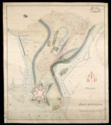
| Parish: | Falkirk ; Gladsmuir | |
| Title: | Battle of Preston: - September 1745. (A plan of the victory of Falkirk Muir fought the afternoon of January 16 [sic, ie. 17th] 1746. - Battle of Clifton Muir, Westmorland. 18th December 1745). | |
| Original Survey: | ca. 1746 | |
| Shelfmark: | EMS.s.164 | |
| Parish: | Glenelg | |
| Title: | Barnera [1719] | |
| Name: | Bastide, John Henri (Engineer) | |
| Original Survey: | 1719 | |
| Shelfmark: | MS.1647 Z.03/05a | |
| Parish: | Glenelg | |
| Title: | Bernera [1719] | |
| Name: | Jelfe, Andrews (Architect) | |
| Original Survey: | 1719 | |
| Shelfmark: | MS.1647 Z.03/05c | |
| Parish: | Glenelg | |
| Title: | Bernera [1719] | |
| Name: | Jelfe, Andrews (Architect) | |
| Original Survey: | 1719 | |
| Shelfmark: | MS.1647 Z.03/06a | |
| Parish: | Glenelg | |
| Title: | Plan of the Fort Barrack of Bernera in Glen Elg 1719 | |
| Name: | Bastide, John Henri (Engineer) | |
| Original Survey: | 1719 | |
| Shelfmark: | MS.1647 Z.03/06b | |
| Parish: | Glenelg | |
| Title: | Plan of the Fort Barrack of Bernera in Glen Elg 1719 [copy] | |
| Name: | Bastide, John Henri (Engineer) | |
| Original Survey: | 1719 | |
| Shelfmark: | MS.1647 Z.03/06c | |
| Parish: | Glenelg | |
| Title: | Plan of the Fort Barrack Bernera in Glen Elg [1719] [copy] | |
| Name: | Bastide, John Henri (Engineer) | |
| Original Survey: | 1719 | |
| Shelfmark: | MS.1647 Z.03/06d | |
| Parish: | Glenelg | |
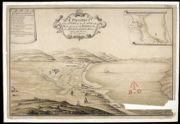
| Title: | A Prospect of that Part of the Land and Sea adjacent to ye Barrack to be Built in Glen Elg | |
| Name: | Bastide, John Henri (Engineer) | |
| Original Survey: | 1720 | |
| Shelfmark: | MS.1647 Z.03/07a | |

| Parish: | Glenelg | |
| Title: | A Prospect of that Part of the Land and Sea adjacent to the Barrack to be Built in Glen Elg [1720] [copy] | |
| Name: | Bastide, John Henri (Engineer) Test, William (Copyist) | |
| Original Survey: | 1762 | |
| Shelfmark: | MS.1647 Z.03/07b | |
| Parish: | Glenelg | |
| Title: | A Prospect of that Part of the Land and Sea adjacent to the Barrack to be Built in Glen Elg [1720] [copy] | |
| Name: | Bastide, John Henri (Engineer) [Test, William (Copyist)] | |
| Original Survey: | 1762 | |
| Shelfmark: | MS.1647 Z.03/07c | |
| Parish: | Glenelg | |
| Title: | Barnera [1719] [copy] | |
| Name: | Bastide, John Henri (Engineer) Gould, Francis (Copyist) | |
| Original Survey: | 1763 | |
| Shelfmark: | MS.1647 Z.03/05b | |
| Parish: | Inverness and Bona | |
| Title: | Inverness in North Brittain | |
| Name: | Petit, Lewis (Engineer) | |
| Original Survey: | [ca.1716] | |
| Shelfmark: | MS.1647 Z.02/78a | |
| Parish: | Inverness and Bona | |
| Title: | Inverness in North Brittain [copy] | |
| Name: | Petit, Lewis (Engineer) | |
| Original Survey: | [ca.1716] | |
| Shelfmark: | MS.1647 Z.02/78b | |
| Parish: | Inverness and Bona | |
| Title: | Inverness in North Brittain [copy] | |
| Name: | Petit, Lewis (Engineer) | |
| Original Survey: | [ca.1716] | |
| Shelfmark: | MS.1647 Z.02/78c | |
| Parish: | Inverness and Bona | |
| Title: | Inverness A Survey of the Castle Anno 1719 | |
| Name: | Jelfe, Andrews (Architect) | |
| Original Survey: | 1719 | |
| Shelfmark: | MS.1647 Z.02/77 | |
| Parish: | Inverness and Bona | |
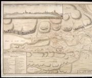
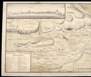
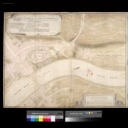
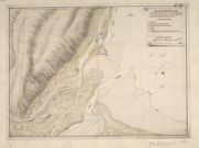
| Title: | A General Survey of Inverness, and the Country adjacent to the foot of Loch-Ness; [inset] West Prospect of Inverness | |
| Name: | Bastide, John Henri (Engineer) | |
| Original Survey: | [ca.1725] | |
| Shelfmark: | MS.1647 Z.02/76a | |
| Parish: | Inverness and Bona | |
| Title: | A General Survey of Inverness, & the Country adjacent to the Foot of Loch-Ness [copy] | |
| Name: | Bastide, John Henri (Engineer) | |
| Original Survey: | [ca.1725] | |
| Shelfmark: | MS.1647 Z.02/76b | |
| Parish: | Inverness and Bona | |
| Title: | A Generall Survey of Inverness, & the country adjacent to the foot of Loch-Ness [copy] | |
| Name: | Bastide, John Henri (Engineer) | |
| Original Survey: | [ca.1725] | |
| Shelfmark: | MS.1647 Z.02/76c | |
| Parish: | Inverness and Bona | |
| Title: | A plan of part of the town of Inverness with a project for Barracks on Castle Hill … | |
| Name: | Romer, John Lambertus (Engineer) [Wade, George (Engineer)] | |
| Original Survey: | 1728 | |
| Shelfmark: | Acc.10497 Wade.58j | |
| Parish: | Inverness and Bona | |
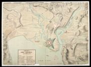
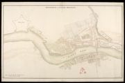
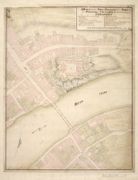
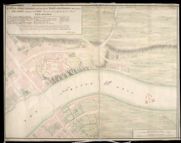
| Title: | A Plan of Fort George wth part of the Town of Inverness 1730 | |
| Name: | Romer, John Lambertus (Engineer) | |
| Original Survey: | 1730 | |
| Shelfmark: | MS.1646 Z.02/33a | |
| Parish: | Inverness and Bona | |
| Title: | A Plan of Fort George with Part of the Town of Inverness [1730] [copy] | |
| Name: | Romer, John Lambertus (Engineer) | |
| Original Survey: | [1730] | |
| Shelfmark: | MS.1646 Z.02/33b | |
| Parish: | Inverness and Bona | |
| Title: | A Plan of Fort George with part of the Town of Inverness 1730 [copy] | |
| Name: | Romer, John Lambertus (Engineer) | |
| Original Survey: | 1730 | |
| Shelfmark: | MS.1646 Z.02/33c | |
| Parish: | Inverness and Bona | |
| Title: | A Plan and Section of Fort George with part of the Town of Inverness [about 1730] | |
| Original Survey: | [ca.1730] | |
| Shelfmark: | MS.1646 Z.02/38 | |
| Parish: | Inverness and Bona | |
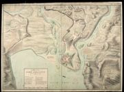
| Title: | A Plan of Fort George, & part of the Town of Inverness, with proper Sections relating to the Fort. Anno 1732. | |
| Name: | Romer, John Lambertus (Engineer) | |
| Original Survey: | 1732 | |
| Shelfmark: | MS.1646 Z.02/34a | |
| Parish: | Inverness and Bona | |
| Title: | A Plan of Fort George and part of the Town of Inverness, with proper Sections relating to the Fort. Anno 1732 [copy] | |
| Name: | Romer, John Lambertus (Engineer) | |
| Original Survey: | 1732 | |
| Shelfmark: | MS.1646 Z.02/34b | |
| Parish: | Inverness and Bona | |
| Title: | Elevation of the main Gate or Entrance on the Rampart to the Fortress [1746] [Proposed Fort George on Oliver's Fort site, Inverness] | |
| Name: | Marcell, Lewis (Engineer) | |
| Original Survey: | [1746] | |
| Shelfmark: | MS.1647 Z.02/79b | |
| Parish: | Inverness and Bona | |
| Title: | Plan of one of the Rooffs of the Double Buildings next the Parade [1746] [Proposed Fort George on Oliver's Fort site, Inverness] | |
| Name: | Marcell, Lewis (Engineer) | |
| Original Survey: | [1746] | |
| Shelfmark: | MS.1647 Z.02/79c | |
| Parish: | Inverness and Bona | |
| Title: | Plans, Elevation & Section of one of the four long Piles of Barracks for Soldiers; Marked No.9 in the General Plan [1746] [Proposed Fort George on Oliver's Fort site, Inverness] | |
| Name: | Marcell, Lewis (Engineer) | |
| Original Survey: | [1746] | |
| Shelfmark: | MS.1647 Z.02/80a | |
| Parish: | Inverness and Bona | |
| Title: | Plans, Elevation & Section of the Officers & Soldiers Guard Rooms, Breweree, Stables &c.; Marked Nos. 7 & 8 on ye General Plan [1746] [Proposed Fort George on Oliver's Fort site, Inverness] | |
| Name: | Marcell, Lewis (Engineer) | |
| Original Survey: | [1746] | |
| Shelfmark: | MS.1647 Z.02/80b | |
| Parish: | Inverness and Bona | |
| Title: | The Governours, Deputy Governour's, Fort Major's & Storekeeper's Houses; Marked Nos. 1 & 2 on the General Plan [1746] [Proposed Fort George on Oliver's Fort site, Inverness] | |
| Name: | Marcell, Lewis (Engineer) | |
| Original Survey: | [1746] | |
| Shelfmark: | MS.1647 Z.02/81a | |
| Parish: | Inverness and Bona | |
| Title: | Plans, Elevation & Section of the Powder Magazine, Magazines for Provisions, Baking Houses, etc.; Marked No.3 in the General plan [1746] [Proposed Fort George on Oliver's Fort site, Inverness] | |
| Name: | Marcell, Lewis (Engineer) | |
| Original Survey: | [1746] | |
| Shelfmark: | MS.1647 Z.02/81b | |
| Parish: | Inverness and Bona | |
| Title: | Plan, Elevation & Section of the Arsenal & Armoury; Marked No. 4 in the General Plan [1746] [Proposed Fort George on Oliver's Fort site, Inverness] | |
| Name: | Marcell, Lewis (Engineer) | |
| Original Survey: | [1746] | |
| Shelfmark: | MS.1647 Z.02/81c | |
| Parish: | Inverness and Bona | |
| Title: | Plans, Elevation & Section of the Hospital; Marked No. 5 in the General Plan [1746] [Proposed Fort George on Oliver's Fort site, Inverness] | |
| Name: | Marcell, Lewis (Engineer) | |
| Original Survey: | [1746] | |
| Shelfmark: | MS.1647 Z.02/81d | |
| Parish: | Inverness and Bona | |
| Title: | Plans, Elevation & Section of a Pile of Barracks for Soldiers; marked No.6 in the Generall Plan [1746] [Proposed Fort George on Oliver's Fort site, Inverness] | |
| Name: | Marcell, Lewis (Engineer) | |
| Original Survey: | [1746] | |
| Shelfmark: | MS.1647 Z.02/81e | |
| Parish: | Inverness and Bona | |
| Title: | Plan for building a Fort at Inverness on the Vestige of an old Fort demolished 1746 [copy] | |
| Name: | Skinner, William (Engineer) Tarrant, Charles (Draughtsman) Thomas Smart (Copyist) | |
| Original Survey: | 1746 | |
| Shelfmark: | MS.1647 Z.02/82a | |
| Parish: | Inverness and Bona | |
| Title: | Plan for building A Fort at Inverness on the Vestige of an old Fort demolished 1746 | |
| Name: | Skinner, William (Engineer) Tarrant, Charles (Draughtsman) | |
| Original Survey: | 1746 | |
| Shelfmark: | MS.1647 Z.02/82b | |
| Parish: | Inverness and Bona | |
| Title: | A Plan of a New Fort design'd for Inverness, Done exactly upon the Old Lines of Olivers Fort; with the additional Outworks of Cover'd-way, Lunettes and Glassis; all which are more fully explain'd in the particular Plans & Sections | |
| Name: | Marcell, Lewis (Engineer) | |
| Original Survey: | 1746 | |
| Shelfmark: | MS.1647 Z.02/83a | |
| Parish: | Inverness and Bona | |
| Title: | [Section of the Double Building; Section of the Single Building; Section upon the Line AB in the General Plan; Profile of the Rampart; Section upon the Line CD in the General Plan; Profile of the Lunette in the Place of Arms; Proposed Fort George on Olive | |
| Name: | Marcell, Lewis (Engineer) | |
| Original Survey: | 1746 | |
| Shelfmark: | MS.1647 Z.02/83b | |
| Parish: | Inverness and Bona | |
| Title: | Powder Magazine Fort George | |
| Name: | Skinner, William (Engineer) | |
| Original Survey: | [ca.1748-62?] | |
| Shelfmark: | MS.1647 Z.02/60 | |
| Parish: | Inverness and Bona | |
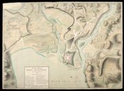
| Title: | Plan of Fort George at Inverness, Shewing it's present Condition. 1750 | |
| Name: | Skinner, William (Engineer) Tarrant, Charles (Draughtsman) | |
| Original Survey: | 1750 | |
| Shelfmark: | MS.1646 Z.02/36a | |
| Parish: | Inverness and Bona | |
| Title: | Plan of Fort George at Inverness, Shewing it's present Condition. 1750 [copy] | |
| Name: | Skinner, William (Engineer) Tarrant, Charles (Draughtsman) Burr, G.D. (Copyist) | |
| Original Survey: | 1750 | |
| Shelfmark: | MS.1646 Z.02/36b | |
| Parish: | Inverness and Bona | |
| Title: | Fort George at Inverness [1750] | |
| Name: | Skinner, William (Engineer) Tarrant, Charles (Draughtsman) | |
| Original Survey: | 1750 | |
| Shelfmark: | MS.1646 Z.02/37a | |
| Parish: | Inverness and Bona | |
| Title: | Fort George at Inverness [1750] [copy] | |
| Name: | Skinner, William (Engineer) Tarrant, Charles (Draughtsman) | |
| Original Survey: | [ca.1750] | |
| Shelfmark: | MS.1646 Z.02/37b | |
| Parish: | Inverness and Bona | |
| Title: | [Shore at Fort George showing tides]; Plan of the Pier | |
| Name: | Frazer, Andrew (Engineer) Frazer, Andrew (Draughtsman) | |
| Original Survey: | [post-1756] | |
| Shelfmark: | MS.1647 Z.02/58 | |
| Parish: | Inverness and Bona | |
| Title: | Fort George in North Britain 1769 | |
| Name: | Skinner, William (Engineer) Sedley, John S. (Copyist) | |
| Original Survey: | [1769] | |
| Shelfmark: | MS.1647 Z.02/59b | |
| Parish: | Inverness and Bona | |
| Title: | A Plan of Fort George North Britain [1769] | |
| Name: | Skinner, William (Engineer) Robinson, David, & Basset, C. (Copyist) | |
| Original Survey: | [1769] | |
| Shelfmark: | MS.1647 Z.02/59c | |
| Parish: | Inverness and Bona | |
| Title: | A Plan of Fort George North Britain [1769] | |
| Name: | Skinner, William (Engineer) Rogerson, William M. (Copyist) | |
| Original Survey: | [1769?] | |
| Shelfmark: | MS.1647 Z.02/59a | |

| Parish: | Inverness, Croy, Daviot and Dunlichity | |
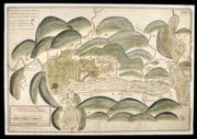
| Title: | A Plan of the Batle of Coullodin moore fought on the 16th. Of Aprile 1746 | |
| Name: | Paterson, Daniel (Engineer) | |
| Original Survey: | 1746 | |
| Shelfmark: | MS.1648 Z.03/30a | |
| Parish: | Inverness, Croy, Daviot and Dunlichity | |
| Title: | A Plan of ye Battle of Colloden between his Majs. Forces Under the Command of his Royall Highness the Duke of Cumberland and the Sctt. Rebels April ye 16 1746 | |
| Name: | Jones, Jasper Leigh (Draughtsman) | |
| Original Survey: | 1746 | |
| Shelfmark: | MS.1648 Z.03/30b | |
| Parish: | Inverness, Croy, Daviot and Dunlichity | |
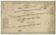
| Title: | A plan of the battle of Culloden and the adjacent country, shewing the Incampment of the English Army at Nairn and the March of the Highlanders in order to attack them by night | |
| Name: | Finlayson, John ? | |
| Original Survey: | 1746? | |
| Shelfmark: | EMS.s.156 | |
| Parish: | Inverness, Croy, Daviot and Dunlichity | |
| Title: | A plan of ye disposition of both army's, in yt. ever memorable battle & defeat of ye rebels by his R.H. ye Duke of Cumberland. Ap. 16, 1746 near Collodon House. | |
| Original Survey: | 1746 | |
| Shelfmark: | EMS.s.157 | |
| Parish: | Inverness, Croy, Daviot and Dunlichity | |
| Title: | A plan of ye disposition of both army's, in yt. ever memorable battle & defeat of ye rebels by his R.H. ye Duke of Cumberland. Ap. 16, 1746 near Collodon House. | |
| Original Survey: | 1746 | |
| Shelfmark: | EMS.s.157A | |
| Parish: | Inverness, Croy, Daviot and Dunlichity | |
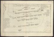
| Title: | A plan of the field of battle, and the adjacent country with the order of His Majesties Army ... as drawn up the 16 April 1746 at the engag[men]t w[ith] the rebels near Cullodon House as also a plan of the rebel army ... distinguishing each clan with thei | |
| Original Survey: | 1746 | |
| Shelfmark: | EMS.s.158 | |
| Parish: | Inverness, Croy, Daviot and Dunlichity | |
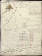
| Title: | The order of the Duke's Army, as they were drawn up the 16 of April 1746 near Cullenden House.. | |
| Original Survey: | 1746 | |
| Shelfmark: | EMS.s.159 | |
| Parish: | Inverness, Croy, Daviot and Dunlichity | |
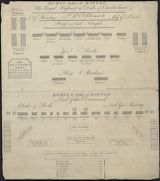
| Title: | Plan exact de la disposition des Troupes Ecossaises sous le Commandement de son A.R.P... | |
| Original Survey: | ca. 1748 | |
| Shelfmark: | Acc.11323 | |
| Parish: | Inverness, Croy, Daviot and Dunlichity | |
| Title: | Map of Culloden Moor and part of the adjacent country : On which are laid down the different roads leading to the field of battle ... the positions and lines of march of the ... armies. Also ancient tumuli, druidical stone circles ... / by J. Gowie. Engra | |
| Name: | Gowie, J. | |
| Original Survey: | 1845 | |
| Shelfmark: | EMS.b.1.21 | |
| Parish: | Inverness, Croy, Daviot and Dunlichity | |
| Title: | Map of Culloden Moor and part of the adjacent country : On which are laid down the different roads leading to the field of battle ... the positions and lines of march of the ... armies. Also ancient tumuli, druidical stone circles ... / by J. Gowie. Engra | |
| Name: | Gowie, J. | |
| Original Survey: | 1845 | |
| Shelfmark: | EMS.b.2.137 | |
| Parish: | Kilmallie | |
| Title: | Description of the forts of Inverloughee. | |
| Original Survey: | 1656 | |
| Shelfmark: | EMS.s.89 | |
| Parish: | Kilmallie | |
| Title: | Barracks at Inverlochy with Officers Houses | |
| Name: | Jelfe, Andrews (Architect) | |
| Original Survey: | 1709 | |
| Shelfmark: | MS.1646 Z.02/32b | |
| Parish: | Kilmallie | |
| Title: | Plan of Fort William at Inverlochy in its present condition Augst. 1709 | |
| Name: | [Dury, Theodore (Engineer)] | |
| Original Survey: | 1709 | |
| Shelfmark: | MS.1646 Z.02/24c | |
| Parish: | Kilmallie | |
| Title: | Plan of Fort William at Inverlochie in Lochaber | |
| Name: | [Dury, Theodore (Engineer)] | |
| Original Survey: | [ca.1710] | |
| Shelfmark: | MS.1646 Z.02/24b | |
| Parish: | Kilmallie | |
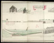
| Title: | [Plan of the Storehouse, Fort William]; The Front of the new Store house as it appears to the Rampart, built 1712, Fort William, H; The Front of the new Store house as it appears to the Parade, Built in ye year 1712, Fort William; The Plan of the new Stor | |
| Name: | Petit, Lewis (Engineer) | |
| Original Survey: | 1712 | |
| Shelfmark: | MS.1646 Z.02/25a | |
| Parish: | Kilmallie | |
| Title: | [Plans of the Soldiers' Barracks, Fort William]; The front of ye Souldiers Barracks as it appears to the Rampart, Fort William, K; The Front of the Soldiers Barracks as it appears to the Parade, Fort William, K; A Plan of the Souldiers Barracks that is ne | |
| Name: | Petit, Lewis (Engineer) | |
| Original Survey: | 1712 | |
| Shelfmark: | MS.1646 Z.02/25b | |
| Parish: | Kilmallie | |
| Title: | Fort William, Anno 1719 [No.1] | |
| Name: | Jelfe, Andrews (Architect) Moore, Thomas (Engineer) | |
| Original Survey: | 1719 | |
| Shelfmark: | MS.1646 Z.02/26a | |
| Parish: | Kilmallie | |
| Title: | Fort William, Anno 1719 [No.1] [copy] | |
| Name: | Jelfe, Andrews (Architect) Moore, Thomas (Engineer) Dodd, Pressick (Copyist) | |
| Original Survey: | 1719 | |
| Shelfmark: | MS.1646 Z.02/26b | |
| Parish: | Kilmallie | |
| Title: | Fort William, Anno 1719 [No.2] | |
| Name: | Jelfe, Andrews (Architect) Moore, Thomas (Engineer) | |
| Original Survey: | 1719 | |
| Shelfmark: | MS.1646 Z.02/26c | |
| Parish: | Kilmallie | |
| Title: | [Plan of] District of Fort Wm. | |
| Name: | [Wade, George (Engineer)] | |
| Original Survey: | 1728 | |
| Shelfmark: | Acc.10497 Wade.58i | |
| Parish: | Kilmallie | |
| Title: | Profiles and Elevations Relating to the Plan of Fort William, 1733 | |
| Name: | Romer, John Lambertus (Engineer) Massey, George & Coombs, Richard (Copyist) | |
| Original Survey: | 1733 | |
| Shelfmark: | MS.1646 Z.02/27c | |
| Parish: | Kilmallie | |
| Title: | [Plan showing fortifications of Fort William and Town of Maryborough.] | |
| Name: | [Wade, George (Engineer)] | |
| Original Survey: | [ca. 1736?] | |
| Shelfmark: | Acc.10497 Wade.58o | |
| Parish: | Kilmallie | |
| Title: | A Plan of Fort William in the Shire of Inverness, with the District as is described by the Occult lines markt with yel=low & bounded by the River Navis. | |
| Name: | [Wade, George (Engineer)] | |
| Original Survey: | 1736 | |
| Shelfmark: | Acc.10497 Wade.58p | |
| Parish: | Kilmallie | |
| Title: | A Draught of the long Soldjers Barrack already built at Fort William, along Nevish Watter side | |
| Name: | Petit, Lewis (Engineer) | |
| Original Survey: | [ca.1744?] | |
| Shelfmark: | MS.1646 Z.02/32a | |
| Parish: | Kilmallie | |
| Title: | Plan of Ground Story of the Long Pile of Barracks at Fort-William, lately Repaired; Plan, Elevation and Section of the Bakehouse Built at Fort-William 1743; Plan and Elevation of the Main Gate proposed to be Built at Fort-William 1744; Plan and Elevation | |
| Name: | Campbell, Dugal (Engineer) | |
| Original Survey: | 1744 | |
| Shelfmark: | MS.1646 Z.02/28a | |
| Parish: | Kilmallie | |
| Title: | Plan, Elevation and Sections of the New Pile of Barracks Ordered to be Built for the Officers at Fort-William | |
| Name: | Campbell, Dugal (Engineer) | |
| Original Survey: | 1744 | |
| Shelfmark: | MS.1646 Z.02/28b | |
| Parish: | Kilmallie | |
| Title: | Plan of the Governour's House at Fort-William with the Closets that is joined to the Gable End coloured Red shewing where the Fire happened | |
| Name: | Campbell, Dugal (Engineer) | |
| Original Survey: | 1744 | |
| Shelfmark: | MS.1646 Z.02/28c | |
| Parish: | Kilmallie | |
| Title: | Plan of the Front on the Entrance to Fort William, representing the Main Gate Way as proposed to be rebuilt with the Wing Walls sustaining the ground of the Rampart on each side of the Entrance. And the manner proposed for forming the Earth Work of the R | |
| Name: | Campbell, Dugal (Engineer) Deleny, John (Copyist) | |
| Original Survey: | [1744] | |
| Shelfmark: | MS.1646 Z.02/27a | |
| Parish: | Kilmallie | |
| Title: | Plan of the front on the Entrance to Fort William, representing the Main Gate Way as proposed to be rebuilt with the Wing Walls sustaining the ground of the Rampart on each side of the Entrance. And the manner proposed for forming the Earth Work of the R | |
| Name: | Campbell, Dugal (Engineer) Field, John (Copyist) | |
| Original Survey: | [1744] | |
| Shelfmark: | MS.1646 Z.02/27b | |
| Parish: | Kilmallie | |
| Title: | Plan of Fort William 1745 | |
| Name: | Campbell, Dugal (Engineer) Tarrant, Charles (Copyist) | |
| Original Survey: | 1745 | |
| Shelfmark: | MS.1646 Z.02/29a | |
| Parish: | Kilmallie | |
| Title: | Plan of Fort William 1745 [copy] | |
| Name: | Campbell, Dugal (Engineer) Deleny, John (Copyist) | |
| Original Survey: | 1745 | |
| Shelfmark: | MS.1646 Z.02/29b | |
| Parish: | Kilmallie | |
| Title: | Plan of Fort William 1745 [copy] | |
| Name: | Campbell, Dugal (Engineer) Deleny, John (Copyist) | |
| Original Survey: | 1745 | |
| Shelfmark: | MS.1646 Z.02/29c | |
| Parish: | Kilmallie | |
| Title: | Plan, Elevation and Sections of additional Barracks of Timber, Ordered by the Duke of Cumberland to be built at Fortwilliam, on the vacant ground near the Governours House, For accommodating of 160 Private Men | |
| Name: | Campbell, Dugal (Engineer) | |
| Original Survey: | 1746 | |
| Shelfmark: | MS.1646 Z.02/30a | |

| Parish: | Kilmallie | |
| Title: | Plan, Elevation and Sections of additional Barracks of Timber, Ordered by his Royal Highness the Duke of Cumberland to be built at Fort William, on the vacant ground near the Governours House for the accomodateing 160 private Men [copy] | |
| Name: | Campbell, Dugal (Engineer) | |
| Original Survey: | 1746 | |
| Shelfmark: | MS.1646 Z.02/30b | |
| Parish: | Kilmallie | |
| Title: | A plan of the Grounds Adjacent to Fort William | |
| Original Survey: | 1748 | |
| Shelfmark: | Acc.3572 | |
| Parish: | Kilmallie | |
| Title: | Plan, Elevation and Section of the South Bastion of Fort William, Shewing the Breach occasiond by the Shooting of Part of the Scarp-Wall. | |
| Name: | Walker, Thomas (Engineer) | |
| Original Survey: | 1751 | |
| Shelfmark: | MS.1646 Z.02/31a | |
| Parish: | Kilmallie | |
| Title: | Plan, Elevation and Section of the South Bastion of Fort William, Shewing the Breach occasion'd by the Shooting of Part of the Scarp Wall [copy] | |
| Name: | Walker, Thomas (Engineer) Gould, Francis (Draughtsman) | |
| Original Survey: | [1751] | |
| Shelfmark: | MS.1646 Z.02/31b | |
| Parish: | Kilmallie | |
| Title: | Sketch of the Ground in the Neighbourhood of Fort William, in the Shire of Inverness, and the Point of Corpach. | |
| Name: | [Frazer, Andrew (Engineer)] | |
| Original Survey: | Post-1780 | |
| Shelfmark: | MS.1649 Z.03/46 | |
| Parish: | Kilmallie | |
| Title: | Fort William; plan shewing the situation and extent of the grant made to the Episcopal Inhabitants by the Board in Decr. 1815 | |
| Name: | Elphinstone, Sir Howard (Engineer) | |
| Original Survey: | 1818 | |
| Shelfmark: | MS.1650 Z.46/22 | |
| Parish: | Kilmallie, Boleskine and Abertarff, Ardersier | |
| Title: | Fort William; Fort Augustus; Fort George, Inverness | |
| Name: | Romer, John Lambertus (Engineer) Jackson, Leonard (Draughtsman) | |
| Original Survey: | [ca.1729-46] | |
| Shelfmark: | MS.1646 Z.02/31c | |
| Parish: | Kilmallie, Kilmonivaig | |
| Title: | [Map of area around Fort William showing] Boundary of the Crown lands; plans, elevations and sections of Ordnance Store and Magazine; Table of Reference [showing] Nature of the Encroachment, How Occupied, Occupiers Name, and Rent & to Whom Paid | |
| Name: | Elphinstone, Sir Howard (Engineer) | |
| Original Survey: | 1818 | |
| Shelfmark: | MS.1650 Z.46/21 | |
| Parish: | Kilmonivaig | |
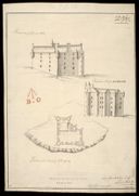
| Title: | Plann of the Castle of Glangary; Prospect of Glangary ABC; Prospect of Glangary BCDEFGH | |
| Name: | Petit, Lewis (Engineer) | |
| Original Survey: | [1714] | |
| Shelfmark: | MS.1648 Z.03/27a | |
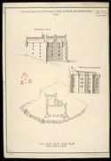
| Parish: | Kilmonivaig | |
| Title: | Plan and Elevations of the Castle of Glengary [copy] 1741 | |
| Name: | Petit, Lewis (Engineer) | |
| Original Survey: | 1741 | |
| Shelfmark: | MS.1648 Z.03/27b | |
| Parish: | Kilmonivaig / Kilmallie | |
| Title: | Plan of Fort William with the country adjacent | |
| Name: | Johnson, Robert (Overseer) | |
| Original Survey: | [ca.1710] | |
| Shelfmark: | MS.1646 Z.02/24a | |
| Parish: | Kilmonivaig, Kilmallie | |
| Title: | Sketch of the Ground in the Neighbourhood of Fort William (in the Shire of Inverness) and the Point of Corpach [copy] | |
| Name: | Parish, Henry W. (Draughtsman) | |
| Original Survey: | 1782 | |
| Shelfmark: | MS.1650 Z.46/20 | |
| Parish: | Kingussie | |
| Title: | A Plan of the Barrack at Ruthven in Badenoch | |
| Name: | Jelfe, Andrews (Architect) | |
| Original Survey: | 1719 | |
| Shelfmark: | MS.1648 Z.03/19a | |
| Parish: | Kingussie | |
| Title: | A Plan of the Barrack at Ruthven in Badenoch [copy] | |
| Name: | Jelfe, Andrews (Architect) | |
| Original Survey: | 1719 | |
| Shelfmark: | MS.1648 Z.03/19b | |
| Parish: | Kingussie | |
| Title: | Ruthvan of Badenock | |
| Name: | Jelfe, Andrews (Architect) | |
| Original Survey: | ca.1719 | |
| Shelfmark: | MS.1648 Z.03/20a | |
| Parish: | Kingussie | |
| Title: | Ruthven of Badenoch [draft] | |
| Name: | Jelfe, Andrews (Architect) | |
| Original Survey: | ca.1719 | |
| Shelfmark: | MS.1648 Z.03/20b | |
| Parish: | Stirling | |
| Title: | [Map showing the intended military roads joining up Stirling with Fort Augustus, etc.] | |
| Name: | [Wade, George (Engineer)] | |
| Original Survey: | [ca. 1724-45?] | |
| Shelfmark: | Acc.10497 Wade.58e | |