Military Maps of Scotland (18th century)
| Name: | Massey, George |
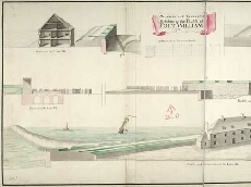
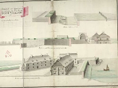
| Title: | Profiles and Elevations relating to the Plan of Fort William, 1733 |
| Original Survey: | 1733 |
| Date on Map: | [ca.1750s?] |
| Description: | 1 manuscript map ; 503 x 1202 mm., on sheet, 532 x 1227 mm |
| Placename: | Fort William |
| Parish: | Kilmallie |
| County: | Inverness-shire |
| Shelfmark: | MS.1646 Z.02/27c |
| Zoom Into Map: | Click on the maps below to order image or view in greater detail. |
All images © Crown Copyright and © National Library of Scotland
Copyright Enquiries & Copies Help