Military Maps of Scotland (18th century)
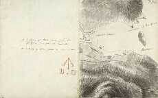
| Title: | [Plan & report of battery site at Campbeltown] |
| Description: | 1 manuscript map ; 231 x 369 mm |
| Placename: | Campbeltown |
| Parish: | Campbeltown |
| County: | Argyllshire |
| Shelfmark: | MS.1649 Z.03/56h |
| Zoom Into Map: | Click on the maps below to order image or view in greater detail. |
 |
All images © Crown Copyright and © National Library of Scotland