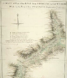
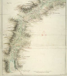
Military Maps of Scotland (18th century)
| Name: | Morrison, George |
| Title: | Survey of part of the road from Sterling to Fort William... |
| Date on Map: | 1749 |
| Description: | 1 manuscript map ; 853 x 480 mm., on sheet, 970 x 532 mm |
| County: | Stirlingshire, Perthshire, Inverness-shire |
| Shelfmark: | MS.1649 Z.03/39a |
| Zoom Into Map: | Click on the maps below to order image or view in greater detail. |
 |
 |
All images © Crown Copyright and © National Library of Scotland