Military Maps of Scotland (18th century)
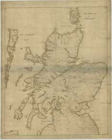
| Title: | [Map of Scotland showing the Forts at Inverness, Fort Augustus, Fort William and Moidart and on which is pencilled the proposed military roads, also the names and numbers of men that could be raised by the various clans] |
| Name: | [Wade, George (Engineer)] |
| Description: | 1 manuscript map : col. ; 740 x 597 mm., on sheet, 798 x 640 mm. |
| Original Survey: | [ca. 1724-45?] |
| Date on Map: | [ca. 1724-45?] |
| Placename: | Scotland |
| Shelfmark: | Acc.10497 Wade.58a |
| Zoom Into Map: | Click on the map to view in greater detail. |
All images © National Library of Scotland