Military Maps of Scotland (18th century)
| Name: | Clayton |
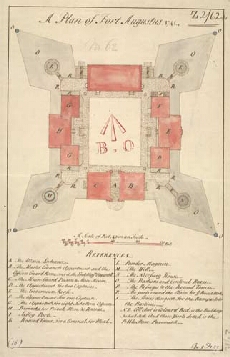
| Title: | A plan of Fort Augustus 1741 |
| Original Survey: | 1741 |
| Date on Map: | 1741 |
| Description: | 1 manuscript map ; 345 x 216 mm., on sheet, 375 x 240 mm |
| Placename: | Fort Augustus |
| Parish: | Boleskine and Abertarff |
| County: | Inverness-shire |
| Shelfmark: | MS.1647 Z.02/62a |
| Zoom Into Map: | Click on the maps below to order image or view in greater detail. |
 |  |
All images © Crown Copyright and © National Library of Scotland