Military Maps of Scotland (18th century)
| Name: | [Wade, George] |
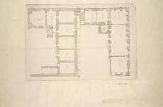
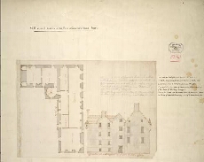
| Title: | [Plans and elevation of the Earl of Gowrie's House, Perth] |
| Original Survey: | [ca. 1724-45?] |
| Date on Map: | [ca. 1724-45?] |
| Description: | 2 manuscript maps ; on sheet, 985 x 692 mm |
| Placename: | Perth |
| Parish: | Perth |
| County: | Perthshire |
| Shelfmark: | Acc.10497 Wade.58l |
| Zoom Into Map: | Click on the maps below to order image or view in greater detail. |
 |  |
All images © National Library of Scotland