Military Maps of Scotland (18th century)
| Name: | Skinner, William [Tarrant, Charles?] |
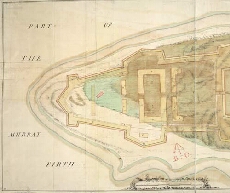
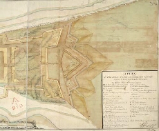
| Title: | Plan of the point of land at Arderseer with the design'd fort as trac'd thereon |
| Original Survey: | [ca.1748-9?] |
| Date on Map: | [ca.1748-9?] |
| Description: | 1 manuscript map ; 436 x 882 mm., on sheet, 462 x 922 mm |
| Placename: | Fort George (Ardersier) |
| Parish: | Ardersier |
| County: | Inverness-shire |
| Shelfmark: | MS.1647 Z.02/57a |
| Zoom Into Map: | Click on the maps below to order image or view in greater detail. |
 |  |
All images © Crown Copyright and © National Library of Scotland