Ordnance Survey map records (1:1,250, 1:2,500 and 1:10,000 scales), Great Britain, 1841-1991 - Help
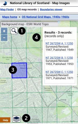
This application shows sheet lines and sheet references for paper maps published at 1:1,250, 1:2500, 1:10,000 and 1:10,560 for Great Britain from 1841 to 1991. This includes both County Series and National Grid maps. It also allows the specific dates/editions of County Series maps of England, Scotland and Wales (1840s-1940s), and National Grid maps of Scotland (1940s-1990s) to be searched.
Main search process


- (optionally) Search using placenames
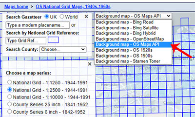
- Choose series / map layers for selection
- Click on area of interest
- View results
Information
This application is particularly useful for:
- Showing the sheet boundaries of these published Ordnance Survey maps. Find out if your site of interest is on one or several maps.
- Identifying the areas that were mapped by Ordnance Survey at their more detailed 25 inch to the mile scale (for cultivated, inhabited areas), and which areas were only covered at the less detailed six-inch to the mile scale. Similarly, from the 1940s, it identifies which areas were mapped at the most detailed post-war scale of 1:1,250, which were mapped at 1:2,500 scale, or which were only mapped at 1:10,000.
- Identifying the particular County Map sheet reference for any location. This is particularly useful at county boundaries, and where county meridians changed over time.
- For 1:2,500 scale maps of urban areas, whether their individual North-West, North-East, South-West, and South-East quadrants were mapped at different dates.
- Finding out which detailed maps were published by Ordnance Survey and when (from the 1840s to the 1990s) for any location in Great Britain. Were there several editions over the years, providing a more detailed chronology for your location or just one or two? This information is particularly of value for site consultants, archaeologists, lawyers, and more generally for those interested in any place and the detailed maps covering it over the past century and a half.
- Finding out whether maps were created by an original survey, by a revision of a previous survey, or (for post-War mapping) revised from the pre-war County Series mapping.
- Listing the exact survey, revision and publication dates for detailed paper sheet mapping for any place.
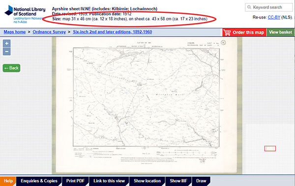
- Discovering how large a particular map of any place will be (for copying), based on its scale and format. See Copies below.
Copyright
All Ordnance Survey mapping is in copyright for 50 years from the end of the year in which the map was published. Four copies up to A4 size may be made under Fair Dealing for private, non-commercial purposes only. Where further copies of these maps are required permission should be sought from Ordnance Survey.
More information on copyright can be found on the Ordnance Survey website.
Copies
We are happy to supply copies (as images, printouts or photocopies) of all the maps listed in this application. The maps are at the following sizes:
- A0 - all County Series six-inch (1:10,560) full sheets (without a NW,NE,SW,SE suffix), all County Series 25 inch (1:2,500) sheets, and all National Grid 1:2,500 double sheets
- A1 - all National Grid 1:1,250 sheets, all National Grid 1:2,500 single sheets, and all National Grid 1:10,000 sheets
- A2 - all County Series six-inch (1:10,560) quarter sheets (with a NW,NE,SW,SE suffix)
Further information on these sizes, prices and copies can be found on our Enquiries and Copies page.
For series maps, the specific map size is also given in the header:

However, please note that copies of in-copyright maps (published in the last 50 years) larger than A4-size or of whole sheets can only be made with permission from Ordnance Survey, or through an Ordnance Survey licensed partner. The National Library of Scotland is an Ordnance Survey Licensed Partner - read about our services for copying in-copyright maps.
To order copies, read our Enquiries & Copies page.
The Gazetteer at the top of the map search panel allows you to locate your area on the map using modern place names from Nominatim, using OpenStreetMap names, as well as the Definitive Gazetteer for Scotland (PDF, 135KB), developed by Bruce M. Gittings, University of Edinburgh, with funding from the Scottish Government. The OSM Nominatim gazetteer is stronger for larger settlements and street names, as well as for its global coverage, whilst the Definitive Gazetteer for Scotland is particularly strong for smaller rural features in Scotland, such as farms and hamlets, mountains, hills, rivers, streams, and lochs. The two gazetteers are searched collectively using the OSMNames technology.
The map will then position to the place that has been selected.
Search by National Grid Reference, Latitude/Longitude or Postcode (top left)
You can search by British National Grid Reference - 2, 4, 6, 8, or 10 figures (ie. 'SE12', 'NT1234', 'TQ123456', 'SD12345678', 'SD1234567890'). You can also search using numeric Grid References as Eastings and Northings (ie. '123456,123456'), or by using latitute, longitude (ie. '52.123,-2.345').
You can also search by postcode. You can enter just the postcode area (ie. 'EH'), district (ie. 'EH9'), sector (ie. 'EH9 1'), or to the full unit (ie. 'EH9 1SL'), either with a space in the middle (ie. 'EH9 1SL') or without (ie. 'EH91SL'). This uses the Ordnance Survey Open Names API.
When you press 'Enter' or the 'Go' button, the map will then position to the National Grid Reference, latitude/longitude, or postcode that has been entered.
Search by historic counties and parishes (top left)
Further down, drop-down boxes allow counties and parishes (based on their names and boundaries in the 1940s) to be searched. When you select a county, the parishes within that county appear as a second drop-down list, allowing you to select the parish.
We gratefully acknowledge OpenStreetMap, Ordnance Survey, and Bruce M. Gittings, University of Edinburgh for allowing us to use these gazetteers, and the Vision of Britain project for allowing us to use these county and parish boundaries.
Rotation
Hold the [Alt] and [Shift] keys, and drag with your cursor (ie. hold the left-hand mouse button down and drag) to rotate. Refresh the page or double-click the rotation arrow (top right) to return to the default rotation.
Printing and Image Export/Download (lower left)
If you click/tap on the print icon ![]() , to the lower left of the screen, then a print panel opens with various options:
, to the lower left of the screen, then a print panel opens with various options:
- Portrait / landscape orientation
- Page size – A4 to A0
- Margin – 0 to 10 mm
- Scale – 1:500 to 1:1,000,000 - set an exact scale for your map
- North Arrow – off or on
At this stage you can also pan/drag or zoom the map image to make sure its covering exactly the right area of interest.
You can then save the image in various formats – JPEG, PNG, PDF, or copy the image to clipboard. It is also possible to print the map directly to a printer.
Location
In the lower-right of the map, the location of your mouse position is shown as a British National Grid Reference, as British National Grid Eastings and Northings, and as longitude and latitude, both in decimal and degrees, minutes and seconds forms.
Linking to the viewer
The URL in your web browser address bar changes dynamically as you zoom and pan the map, and when you alter visible map layers and overlays. You may copy or bookmark the URL in your web browser address bar to save the current viewer location, overlay layer and zoom level.
Application
This application uses OpenLayers as its main interface, as well as GeoServer for Web Feature Services.
We have released the OpenLayers code behind this viewer on Github for onward use. Please see the GeoCart 2018 - ANZMapS Historical Maps Online Workshop, for a set of freely downloadable basic OpenLayers viewers with code and notes.
Please email maps@nls.uk for further assistance, or to provide general comments/feedback.

