Kitchener's Survey of Cyprus, 1882
Introduction

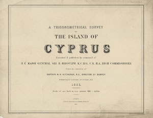
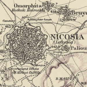
This set of maps represents the first full triangulated survey of the island of Cyprus, and it was the most accurate map of the island when published. The maps are very detailed, marking roads, tracks, and telegraph lines, and locating vineyards, monasteries, ruins, sheepfolds, springs, wells and aqueducts. Towns and villages are identified as being Christian or Muslim, and are given both their Greek and Turkish names. The set consists of a title sheet and 15 map sheets at a scale of one inch to the mile, and are supplemented with a single-sheet index map at a scale of five miles to the inch.
The individual sheets can be viewed using a graphic index covering Cyprus, or view the set as a seamless layer on a Google maps base.
Background
In June of 1878, the Congress of Berlin took place where the "Great Powers" negotiated over the distribution of the Turkish possessions in the Balkans and elsewhere following the Russo-Turkish war of 1877-78, in which Russia liberated almost all Ottoman European possessions. Through independent agreements with Russia and Turkey, Britain was given administration of Cyprus. As a result of these negotiations the island of Cyprus was ceded to Britain and came under the control of the Foreign Secretary, the Marquis of Salisbury, in 1878.
During the three hundred years of Ottoman occupation, there had been no detailed surveys or technical advances in the land mapping of Cyprus. Some considered the "best" existing map at the time of possession as that by the Venetian artist Giacomo Franco, printed in about 1570. The Foreign Office immediately recognized that a proper survey of the island of Cyprus was required. Kitchener was recommended to take on the survey work based on his recently completed trigonometric survey of Palestine. Kitchener's Palestine survey was recognized as a model of its kind and one of the first where difficult terrain had been mapped with consistent accuracy.
Kitchener's remit was to produce a survey of the island of Cyprus that would meet the requirements for administrative and revenue purposes. The administrative map was to be produced at a scale of one inch to the mile, and the revenue map at either four or six inches to the mile. The map set presented here are those that were used for administration purposes.
The Survey


The trigonometric survey was constructed around a baseline, proposed by Kitchener, that lay in the plain to the north of Nicosia. This baseline was accurately surveyed and constructed between the 18th of October to the 15th of November, 1878. It was 19,726.652 feet long and permanent masonary stations were erected at each end of the line. Measurement of the baseline was carried out using a 100-foot chain supplied by the Ordnance Survey.
From each end of the baseline, observations were made of clearly defined adjacent triangulation points. These could be triangulation cairns constructed on the tops of hills from which further points could be seen or other notable landmarks such as towers and churches. Angular measurements were made to the adjacent triangulation points and adjusted for altitude. A network of triangles was constructed outward from the baseline and over time the whole island was covered with a series of 137 linked and angularly measured triangles. A diagram of the full triangulation is reproduced in Shirley (2001).
Every part of the island was visitied and field work was carried out from simple camps. Points suitable for trigonometrical stations were visited and, where necessary, stone cairns built six to ten feet high. The stone cairns were whitewashed to improve their visibility at a distance. Mirrors were used to flash signals between the triangulation points allowing rounds of angles to be taken with a theodolite. These angles to visible triangulation points were plotted on sheets and the observing location was defined by the intersection point of lines traced back from three or more of the observed triangulation points. From this triangulation of location the distances between the points were then calculated.
Daily excursions were made from each camp site where subsidiary observations or further triangulations were made at right angles to the primary lines that join the key triangulation points. These observations included the location of village towers, churches, hill tops, prominent trees, river junctions, etc. The task of tracing points within an 8 to 10 mile radius of the camp was divided between surveyors who sketched in the details of their allotted area by interpolation with a prismatic compass. The 100-foot chain may have been used to measure distances from the primary lines and the results incorporated into the daily record.
To determine local heights, the surveyed lands were contoured and these contours were connected to the sea at Famagusta and Larnaka. Traverses and levelled lines were taken from Famagusta and Larnaka to a benchmark in Nicosia. The height of this benchmark was determined to be 461.5 feet above mean sea level. The location of mean sea level was determined from data collected using a tide gauge installed at Famagusta by Staff Commander J. Millard of the Royal Navy. From the benchmark at Nicosia the heights of survey points throughout the triangulation were determined.
Place Names
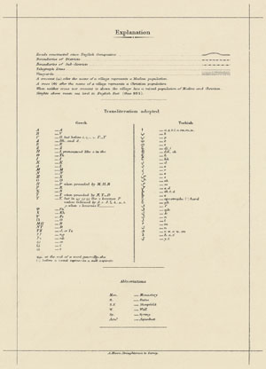
In general the process of recording correct names to localities was very difficult as the Greek and Turkish names were often different or were expressed in some local dialect. The camp surveyor generally needed a local guide and interpreter to help determine names, and to get advice on the significnance of historical sites and archeological remains. Kitchener attempted to collect and transliterate as many local names as possible. This list extended beyond the names of towns, rivers and villages, to include the names of localities, small streams, hills, etc. A guide to the transliteration from Greek and Turkish used to construct the names printed on the final maps is included in the map legend on Sheet 15. Each town and village is marked with transliterations of both its Greek and Turkish name. The predominant religion of the population of a village or town is identified by a symbol after the place name. An upward crescent signifies a Muslim population, a cross signifies a Christian population, and no sysmbol signifies a mixed population of Muslim and Christian.
Publishing
In December 1880 Lieutenant S.C.N. Grant was appointed as assistant Director of Survey to help Kitchener with the detailed work needed to complete the map. In June 1881 Kitchener visited London taking a specimen of the one inch to the mile map to Mr Stanford of Charing Cross to negotiate terms for the publication of the map. An agreement was made between the Crown Agents and Mr Stanford that his company should engrave the maps on 15 sheets, add the hill shading by lithography, and then publish the maps.
By 1882 initial sheets were being sent to Standford's for engraving. In 1883 when Ketchener left for Egypt to take up a new post, Lieut. Grant was appointed Director of Survey and he completed the preparation of the map for engraving and publication by Stanford. On completion of the detailed lettering, hill-shading and checking of proof sheets, the maps were finally published in April 1885. The map was engraved on 16 copper plates including the title page. An additional sheet with an index map at a scale of 5 miles to the inch was added to complete the set. The printed sheets could be bound to form an atlas, and were available as plain sheets or coloured sheets mounted on a linen backing.
Further reading
Rodney Shirley, Kitchener's Survey of Cyprus 1878-1883 (Nicosia, 2001)
