County maps, 1580s-1950s
| Name: | Gordon, Robert, 1580-1661 Pont, Timothy, 1560?-1614? |
| Title: | Fyffe imperfect, M.T.P. : [and], Pt. of the Par. of Abyrnathy. Pt. of the Par. of Abyrnathy. Fife imperfect. Part of the parish of Abernethy |
| Imprint: | [ca. 1636-52] |
| Pagination: | 2 manuscript maps : 285 x 375 mm. and 145 x 76 mm. |
| Shelfmark: | Adv.MS.70.2.10 (Gordon 54) |
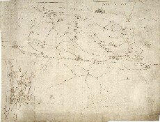
| Notes: | Pont's map is shown to the lower left, pasted on to Robert Gordon's larger map of Fife. Pont's map shows the Firth of Tay in the north (top). In the west is the mouth of the Iern R:[iver] (River Earn), whilst in the east, the abbey at Balmerinoch (Balmerino) is depicted. Inland the map includes the Ochil Hills as far south as Month (Mount Hill) in the east and Weddersbie, just west of Collesie, in the west.
Pt [part] of the Par:[ish] The other, to the south of the map says: m[ar]ching [wi]th the paresh View the Pont Maps website. View maps by Blaeu and Robert and James Gordon. |
| Zoom Into Map: | Click on the map to view in greater detail. |