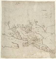
| Notes: | This map by Timothy Pont, overwritten by Robert Gordon, covers both shores of the Dornoch and Cromarty Firths as well as Tarbat Ness in Easter Ross, with the western limits running from Invergordon north-west to Loch Achnacloich, and then running north-east from there to Edderton. - This map was once believed to be by Robert Gordon (hence its title '[Gordon] 20'), but has now been identified as the work of Timothy Pont (Stone, 1974).
- As the compass rose indicates this map is oriented with north towards the right hand margin. This compass and its associated set of east-west and north-south parallel lines may have been drawn later by Gordon. In addition, there is evidence that Gordon has over-written parts of this map and added hill shading.
- Note that the townscape of the ancient royal burgh of Tane (Tain), with its collegiate church of St Duthac, is depicted in some detail. Other settlements are located by a range of typical Pont symbols.
- Pont has drawn carefully several castles on this sheet. See, for example, Cromardy Cast:[le] (Cromarty Castle, lower left, demolished in 1772); and Balnagoun Castell (Balnagown Castle, centre), which had been the home of the chiefs of Clan Ross since 1372, and still survives.
- Note the Abbey at Fearn in the centre of the peninsula. This dates from the late 13th century and was 'Premonstratensian', meaning that it was home to monks of an order founded in 1120 at Premontre, France. The church of Fearn Abbey survives as the parish church.
- No other Pont map includes this area.
Several of Robert Gordon's manuscript maps include at least part of this area: 2, 3, 4, 10, 16, 17, and 18. » - The information on this map was used in part by Joan Blaeu for his printed maps of Extima Scotiae and Moravia. His Southerlandia also overlaps the area.
View the Pont Maps website. View maps by Blaeu and Robert and James Gordon. |