County maps, 1580s-1950s
| Name: | Pont, Timothy, 1560?-1614? |
| Title: | [South Uist; Inverkeithing] - Pont 36 (front) |
| Imprint: | [ca. 1583-96] |
| Pagination: | 1 manuscript map ; 19 x 26 cm. |
| Shelfmark: | Adv.MS.70.2.9 (Pont [36]) |
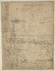
| Notes: | This complex manuscript contains 4 maps together with a substantial amount of text. The front of the sheet has 2 maps of South Uist, Pont <36>(1) and (2) and a map of Inverkeithing, Pont <36> (3). Pont <36>(1) shows part of the island of South Uist in the Western Isles, south of a line joining Verran Island and Loch Altabrug in the west and Corodale Bay in the east. Thus, south is towards the left hand margin. Above this lies Pont <36>(2) depicting a small map of the area of the southwest coast of South Uist around the settlements of Baysdale (Boisdale) and Smeircleat. Below this lies Pont <36>(3) showing the town and Bay of Inverkeithing in Fife. This is a very small but detailed sketch of this town and its harbour on the north coast of the Firth of Forth. On the reverse side of the sheet, Pont <36> (back), is a map of Linlithgow and West Lothian, Pont <36>(4).
View the Pont Maps website. View maps by Blaeu and Robert and James Gordon. |
| Zoom Into Map: | Click on the map to view in greater detail. |