County maps, 1580s-1950s
| Name: | Pont, Timothy, 1560?-1614? |
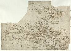
| Title: | [Lower Glen Almond; Strathearn] - Pont 21 |
| Imprint: | [ca. 1583-96] |
| Pagination: | 1 manuscript map ; 26 x 37 cm. |
| Shelfmark: | Adv.MS.70.2.9 (Pont 21) |
| Notes: | There are two separate maps of parts of Perthshire on this sheet, separated by a faint ink line. They are known as Pont 21(1) and Pont 21(2). Pont 21(1) shows the River Almond from a point just west of Perth (not shown) in the east to the Sma' Glen (not named on the map), west of Butthendy (Buchanty) in the west - a distance of about 15km. South of the river, the map extends to Cluthy (Clathy). Pont 21(2) includes the drainage basin of the River Earn from its headwaters west of Loch Eryn (Loch Earn) in the west to a point just east of Duply Cast.[le] (Dupplin Castle) near Aberdalgie, south west of the town of Perth (not shown) in the east. The northern margin encloses Binchoynie Hill (Ben Chonzie, a 3,048ft hill) and the area around Loch Turret. Along the southern margin can be seen Blackford, south west of modern Auchterarder, and the Water of May around Path of Condie in the south east. Pont 21(1) Lower Glen Almond
Pont 21(2) Strathearn
The Draught of Strath Erin Glen cuyrnan or the hellish
View the Pont Maps website. View maps by Blaeu and Robert and James Gordon. |
| Zoom Into Map: | Click on the map to view in greater detail. |