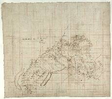
| Notes: | Situated to the south of the Cairngorm Mountains and north of the River Garry, this map extends from Blair Castle in the east to Loch Eyracht (Loch Ericht) in the west. This area includes a northerly part of what is now Perth and Kinross Council area. Pont shows the boundary between Badenoch and Atholl as a dotted line running from the south west to the north east. - The map is titled (top left, upside-down) in the hand of Sir Robert Sibbald Mapp of Garry & its Branches. A notable feature is Pont's careful naming of numerous physical features - hills and rivers in particular. Many of these names were ignored by later map makers such as Robert Gordon and Joan Blaeu in favour of place names relating to human habitation.
- Two grids are drawn over the map. The first, in brown, was possibly drawn by Pont to aid his mapping. The second grid, in red, was probably drawn as an aid in the subsequent copying of the map.
- The attractive thumbnail sketch of Blair Castle (right), the seat of the Dukes of Atholl, is believed to represent accurately the building as it was at the time of Pont's visit. The structure later suffered much damage when stormed by troops loyal to Oliver Cromwell in 1653. It was extensively restored in the 18th and 19th centuries and is much altered from Pont's day.
- See also Pont 25 (back), which includes the southern half of this area, and Pont 23 (front) for a portion of the south east. A very small part of the south east of this map is also included on Pont 20.
» The Gordon manuscript map with the most comparable information to Pont 19 is his sheet 6 (which has 15 names, two of which are not present on the equivalent area of Pont). Less relevant Gordon sheets are: 2, 4, 5, 25, 40 and 41.
» The area is covered by the printed Blaeu map of Braid-Allaban (1654). View the Pont Maps website. View maps by Blaeu and Robert and James Gordon. |