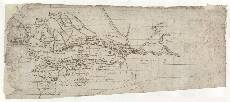
| Notes: | The larger of the two maps on this sheet, Pont 18(1), shows the whole of Loch Tay. It depicts the settlement of Kyllym (Killin) and Glen Dochart at the south west end of the loch (left). At the north east end (right) is the River Tay and Weemh (Weem) castle, just west of Aberfeldy. At the top of the sheet is a profile drawing of Ben Lawers (3,984ft). This may be compared with the slightly different profile on Pont 7. At the bottom of the sheet is Glen Beich which leads into Loch Earn (not shown). The second map on the sheet, Pont 18(2) to the right of this image, is a small, faintly drawn map of the area of Month Kyin (Mount Keen) and the upper part of Glen Tanar, south east of Ballater, Aberdeenshire. This small manuscript was originally part of sheet Pont 7, which also maps Mount Keen and Glen Tanar, but was later cut from it. - From an examination of the handwriting and inks used on this map we know that Robert Gordon added extra place names and trees, and over-wrote Pont's faded original hand in many places. And it was probably Gordon who re-drew the alignment of the River Tay near Weem (right).
- Pont has depicted woodland in several places around Loch Tay, using characteristic tree symbols.
- This map contains some interesting notes. For example, in Loch Tay we find one of Pont's several notes that refer to fishing. It reads:
Fair
Salmonds
Trouts
EEles
and pearle[s]
in Loch Tay Another says: a King
drouned
in Lochtay To the south of Loch Tay, a further note reads: the burnes falling
in Loch Tay ar[e] steep & glennish - Ballach (Balloch) Castle (centre) was the seat of the Campbells of Glenorchy, later Earls of Breadalbane. The elongated building shown by Pont had been enlarged only a few years before his visit. It was rebuilt as Taymouth Castle in the 19th century. Hence, Pont's depiction of the original building is all the more valuable.
- The island at the east end of Loch Tay was granted to Scone Abbey in 1122 by King Alexander I to establish a priory in memory of his wife Sybilla. It is not known whether it was built. The existing ruins were a fortified residence built by the Campbells of Glenorchy in the 15th and 16th centuries.
- See Pont 23 (front) for additional coverage of the north-eastern part of map 18(1), and 7(2), for the area shown by 18(2).
- The most relevant manuscript maps by Robert Gordon which contain comparable information to map (1) are: 4, 6, and 40. However, these maps add relatively little to Pont's work.
- Blaeu's printed map of 1654, titled Braid-Allaban, includes this area, but, again, is less detailed than Pont.
View the Pont Maps website. View maps by Blaeu and Robert and James Gordon. |