County maps, 1580s-1950s
| Name: | Pont, Timothy, 1560?-1614? |
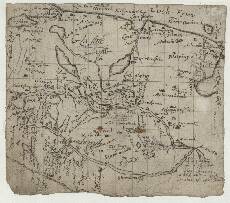
| Title: | [Argyll, north of the Crinan Canal] - Pont 15 (front) |
| Imprint: | [ca. 1583-96] |
| Pagination: | 1 manuscript map ; 15 x 14 cm. |
| Shelfmark: | Adv.MS.70.2.9 (Pont 15) |
| Notes: | This is a small map of an area between Loch Fyinn (Loch Fyne) in the east, and Loch Craignish on the Sound of Jura in the west. On the southern boundary is Loch Gilp and the area just south of Dunadd on the Avon AD (River Add).
View the Pont Maps website. View maps by Blaeu and Robert and James Gordon. |
| Zoom Into Map: | Click on the map to view in greater detail. |