County maps, 1580s-1950s
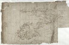
| Name: | Pont, Timothy, 1560?-1614? |
| Title: | [Mid-Argyll; from Dunoon to Inverary and Loch Awe] - Pont 14 |
| Imprint: | [ca. 1583-96] |
| Pagination: | 1 manuscript map ; 31 x 24 cm. |
| Shelfmark: | Adv.MS.70.2.9 (Pont 14) |
| Notes: | This map covers a large area of south and mid Argyll, from Loch Aw (Loch Awe) in the north (top) southeast to Loch Fyne and the Firth of Clyde. In the southwest (bottom left) is the northern part of the Island of Bute. To the east are Glen Fyne (top right) and Loch Gherr (Gare Loch, bottom right).
View the Pont Maps website. View maps by Blaeu and Robert and James Gordon. |
| Zoom Into Map: | Click on the map to view in greater detail. |