County maps, 1580s-1950s
| Name: | Pont, Timothy, 1560?-1614? |
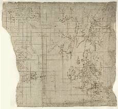
| Title: | [Loch Linnhe, Loch Eil and Loch Leven; Glen Lonan to Loch Etive; Muckairn; Strachur] - Pont 12 (front) |
| Imprint: | [ca. 1583-96] |
| Pagination: | 1 manuscript map ; 33 x 29 cm. |
| Shelfmark: | Adv.MS.70.2.9 (Pont 12) |
| Notes: | This manuscript consists of 5 maps of separate areas. Maps (1)-(4), on the front of the sheet cover four separate areas. 12(1) shows Loch Linnhe, Loch Eil and Loch Leven, the northwest end of Glen Coe, and the coast southwestwards towards Appin. Map 12(2) of Glen Lonan and Loch Etive (Muckairn) lies in the bottom right of this image, covering an area of Muckarne (Muckairn), east of Oban and south from Loch Etive, including the villages of Connel and Taynuilt today. It includes Glen Lonan and an area as far south as Kilmoray (Kilmore). Its place-names are written at a right angle to those on map 12(1). 12(3) covers part of Glen Branter and Glen Shellish, truncated by the left hand edge of the sheet. It includes Glen Branter at the north end of Loch Eck, but this fragment only contains 6 place-names. A little lower down, 12(4) shows the headwaters of the River Cur, just southeast of Strachur, Argyll. Two parallel lines running across the sheet separate maps (3) & (4) from map (1).
the lenth of Cowell is The shorter, fainter note appears to relate to land ownership. It says: Muckarn View the Pont Maps website. View maps by Blaeu and Robert and James Gordon. |
| Zoom Into Map: | Click on the map to view in greater detail. |