County maps, 1580s-1950s
| Name: | Pont, Timothy, 1560?-1614? |
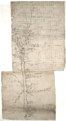
| Title: | [The Great Glen and Glen Garry] - Pont 5 |
| Imprint: | [ca. 1583-96] |
| Pagination: | 1 manuscript map ; 64 x 35 cm. |
| Shelfmark: | Adv.MS.70.2.9 (Pont 5) |
| Notes: | From Inverness in the east this long thin map runs southwestwards along Glen More (or Glen Albyn as it has been called) and includes Loch Ness, Glen Garry, and the west end of Loch Lochy.
H[eir] was my lord ... slayed be the laird of Glenkarris ... of ...
Cast[rum] Virginu[m] means 'Maidens' Castle'. Alat[a] Cast[ra] is a Latin version of the Greek name of a fort described by the 2nd-century writer Ptolemy. It means 'winged camp'. Castle Urquhart, now an impressive ruin, was a strategically important stronghold on the site of an earlier Pictish fort. The surviving tower shown at the left of Pont's view was probably built after the royal grant of 1509 to John Grant. We might note that the famed Loch Ness 'monster' is not depicted!
View the Pont Maps website. View maps by Blaeu and Robert and James Gordon. |
| Zoom Into Map: | Click on the map to view in greater detail. |