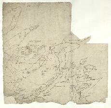
| Notes: | This map is the most northerly of all the Pont manuscripts, depicting the far north west of Sutherland, part of what is now Highland Region. - The area is shown to be relatively sparsely populated, and the main features which stand out are mountains and a coastline indented with large lochs (Loch Eriboll and Loch Tongue (Kintail))
- There are some interesting descriptive remarks, such as many sea fowles build heir off Faro head (Faraid) (top left), and guid corn and fishing by ylen Hoa below.
- The map contains both the familiar plan view of territory as well as profiles of mountains as observed by Pont from the ground. Although exaggerated, some of these mountain profiles are distinctive sketches of real hills, such as Bin Loyall (Ben Loyal, lower right). Morris (1986) has used this profile to determine the locality where Pont was drawing: the eastern shore of Loch Loyal.
- There is a drawing of Balnakill (Balnakeil House) (centre left) and the adjacent church of Durness parish. Balnakeil translates into English as 'Township of the Church', and in the medieval period the revenues of the church and farm belonged to the bishops of Caithness. The church was rebuilt in 1619. The house, which in Pont's time belonged to William Mackay, was rebuilt in the 18th century, but preserves ancient cellars, and an adjacent watermill replaces the two indicated by Pont.
- Most of this map is duplicated on Pont 2 (front), and a small part in the bottom left on Pont 3.
- [Gordon] manuscripts 2, 3, and 11 also overlap with this area.
- Blaeu's engraved map, Strath-Navernia (1654), covers most of the area of Pont 1.
View the Pont Maps website. View maps by Blaeu and Robert and James Gordon. |