County maps, 1580s-1950s
| Name: | Mathieson, John |
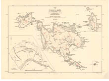
| Title: | Map of St Kilda or Hirta and adjacent islands… |
| Imprint: | [Southampton] : Ordnance Survey, 1928. |
| Pagination: | 1 map ; 620 x 836 mm. |
| Shelfmark: | EMS.s.678 |
| Zoom Into Map: | Click on the map to view in greater detail. |